


Nepal needs weather stations in the Himalaya

This year’s monsoon season showed that precipitation is moving higher up the mountains to the trans-Himalayan valleys, creating a whole new dimension of flood danger downstream.
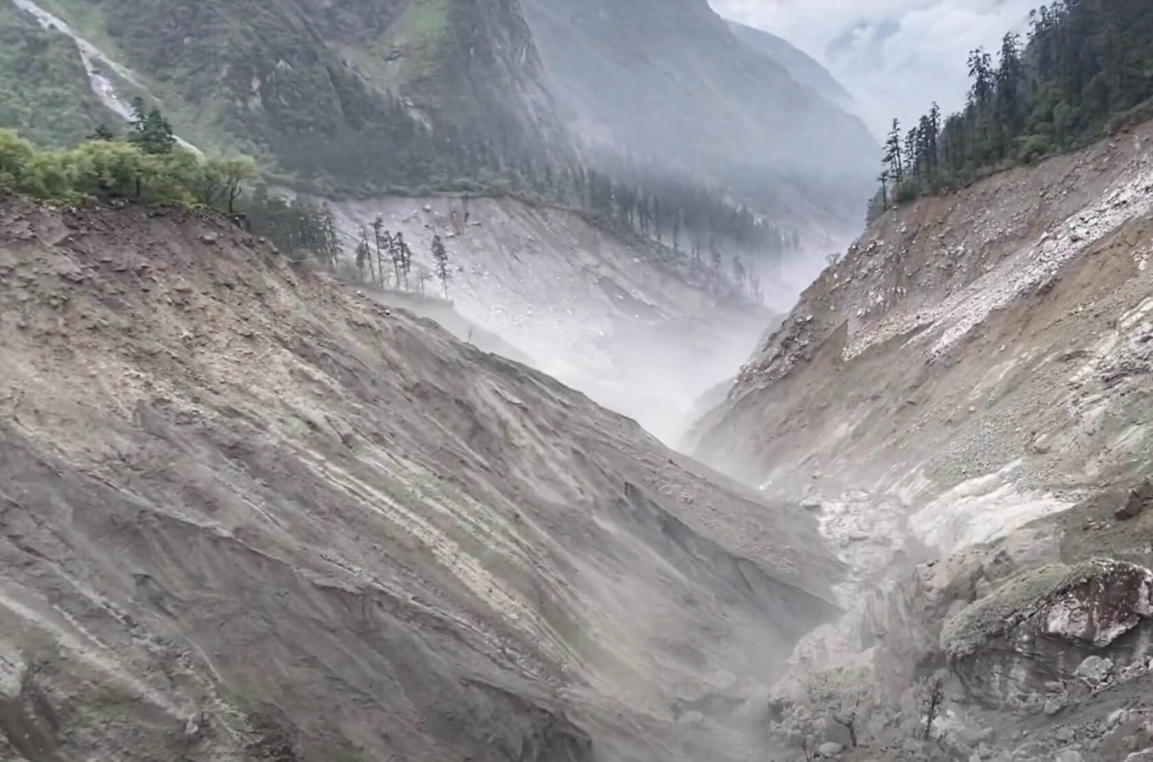
More rain is falling where it did not use to in rain-shadow regions like in Manang, Mustang, Dolpo. Heavy precipitation on loose glacial deposits have unleashed catastrophic debris flows like what is happening on the Melamchi watershed this season.
Some of these extreme weather events can be attributed to climate change, and underlines the need to be prepared for even worse floods in future. For this, we urgently need weather forecasting systems at higher altitudes, hazard mapping and early warning systems.
Heavy rainfall since June and the ensuing floods clearly showed that we lack high altitude weather stations above 3,000m. And even the monitoring stations at lower altitudes did not analyse the recorded data in time and transmit them in a timely manner.
The Department of Hydrology and Meteorology has installed only 12 weather and precipitation monitoring stations above 3,000m, out of 282 such stations across the country. Mustang district has 6 precipitation stations, Gorkha and Manang each have two stations, and there are only one in Doti and Jumla.
These numbers are insufficient given Nepal’s topography and the rapidly changing global climate. The lesson from this year’s floods is that every hydropower or infrastructure project needs to install its own automatic precipitation station in its upper catchment for real time data and early warning.
The rainfall station at Sermathang of Sindhupalchok did record 110.2 mm rainfall in 24 hours on 11 June, but this data was not analysed in time to transmit a warning and prevent floods. If it had, we would have known that a cloudburst of that magnitude in terrain weakened by the 2015 earthquake could spell disaster. Precautions could have been taken downstream in the Melamchi-Indrawati valley, lives saved, and damage reduced.
Nepal has four main glacier-fed river basins: Kosi, Gandaki, Karnali and Mahakali, and 19 other sub-river basins. The catchment areas of these rivers also stretch across the Himalaya into China. There are 3,808 glaciers and 2,070 glacial lakes in Nepal. And then there is also permafrost above 5,000m. (Map, below)

Nepal’s rivers are fed by groundwater discharge, monsoon rains, and glacial melt. However, the hydrological responses of snow-covered and glaciated zones are distinct from other areas. Debris deposits from past glacial advances behave differently when exposed to heavy rainfall, as we continue to witness in Bhrumathang region of the Melamchi River since June.
Climate change is now affecting both the monsoon dynamics and the state of snow/glacier in the Himalaya, and we have to aware and prepared for the consequences.
Besides extreme weather events, the geological structure of the watershed also needs to be taken into account so that a detailed risk assessment can be made before embarking on expensive water supply projects like Melamchi, and deciding on the location of future hydropower plants, bridges and roads.
Past studies had already declared many areas of the Melamchi watershed as a hazardous zone and not suitable for construction of houses and other infrastructure. If such warnings had been heard and timely precautions taken, the damage this monsoon would have been considerably less.
Based on the Department of Hydrology and Meteorology, all Nepal maximum and minimum air temperatures increased by 0.56 oC and 0.02 oC per decade from 1971 to 2014. The warming is higher in the Himalayan region than elsewhere. This means that even under the best-case scenario, the Himalaya could lose up to one-third more of its permanent ice during this century.
This means increased hazard from snow and ice avalanches, flash floods due to the discharge of supra-glacial lakes, or Glacial Lake Outburst Floods (GLOFs). There is a danger that these disasters to be more intense and frequent as weather systems change.
In October 2014, the power cyclone Hudhud which measured 2,000km in diameter spun out of the Bay of Bengal and made a direct hit on Central Nepal, dumping rain and snow in the Annapurna region, killing 43 people (including trekkers) in blizzards and avalanche.
Indian and Nepali meteorologists had sent out warnings and forecast heavy precipitation, however due to the lack of proper risk reduction mechanisms and safety management skills, casualties were high.
In January 2020, four Korean trekkers and three Nepali guides were swept away by an avalanche at Deurali on the Annapurna Base Camp trek. Although there has always been risk of avalanches in the Himalaya, very heavy snowfall with warming trends have increased the objective danger. Proper local forecasts could have warned trekkers in the area of the heightened risk.
In two of the worst disasters in recent times, 42 people, including 13 Japanese trekkers, were killed in November 1996 when the Gokyo region near Mt Everest was hit by an unprecedented blizzard. In October 2005, 18 people including trekkers were killed in snow storms and avalanches in Manang.
These and many other disasters show that post-monsoon cyclonic storms hitting Nepal at the peak of the trekking season must be more closely monitored and their local impact forecast accurately so early warning for specific areas can be issued. Fatalities can be reduced by finding ways to warn local communities, lodge owners, local governments, trekking outfits and guides, and build local capacity in search and rescue.
The importance of having high altitude weather and snow monitoring stations was also shown by the sudden increase in snow depth (1.65m) on the Rikha Samba Glacier in Mustang (5,200m) during the Hudhud cyclone on 15 October 2014. (See graph below.)

A similar snow depth sensor on Yala Glacier in the Langtang Valley also showed 0.5m increase in snow depth on the same day. Although the purpose of these stations were for scientific research into the impact of climate change on snow depth, and not for hazard prevention, the data could have been used for early warning about storm hazards in the high mountains.
The lesson for us is that it is essential and urgent to strengthen the capacity of snow hazard risk reduction by letting local governments and communities have access to real-time data.
The Himalaya has seen historic GLOFs, and these debris flows are expected to be bigger and more frequent with climate change. On 4 August 1985, the Dig Tso glacial lake overtopped after an avalanche and swept down the Dudh Kosi, killing three and destroying a hydropower plant, 14 bridges and 35 houses.
The disaster prompted the government to start studying glaciers and glacial lakes in Nepal, and major GLOF events have been recorded (see table). Risk reduction has also involved lowering the water level of Tso Rolpa glacial lake in Rolwaling by 3m and Imja glacial lake in Khumbu by 3.4m.

A recent study by the International Center for Integrated Mountain Development (ICIMOD) and United Nations Development Programme (UNDP) classified 47 glacial lakes in Nepal, China and India as potentially dangerous. Of these, 25 are in China, 21 in Nepal and 1 in India. Of the potentially dangerous lakes in Nepal, 17 are on the Arun River basin, out of which only 4 are in Nepal and 13 upstream in China.
Most of the immediate risk to infrastructure and settlements in the Arun River, therefore, emanate from across the border and this calls for trans-boundary cooperation in early warning.
On 18 June 2021, heavy rainfall triggered landslides blocked the Rongsi River in China, a tributary of the Tama Kosi. The Chinese authorities informed Nepal about the possibility of a flashflood in case the landslide dam was breached.
Fortunately, the Chinese safely drained the lake averting the possibility of a flood. In such events also, a high altitude weather and snow monitoring station would have provided early warning so that precautions could be taken downstream.
Rijan Bhakta Kayastha, PhD, is a glaciologist at the Himalayan Cryosphere, Climate and Disaster Research Center of Kathmandu University.
