

Kathmandu Valley’s geography gives it several strategic advantages. It is too high for malaria, but too low for much snow and ice. That, and its location between north Indian population centres and the high Himalayan passes, positioned it perfectly as a historic entrepôt.
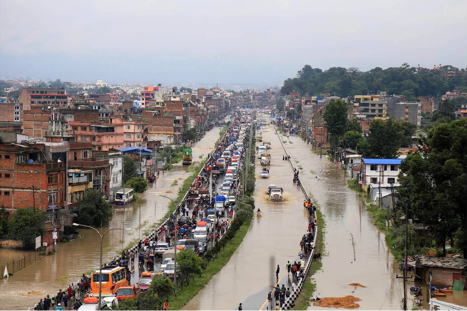
But the Valley also suffers from earthquakes and flooding. The floods hit almost every year during the monsoon, and used to bring soil-restoring silt to the farms, but more recently have delivered mostly damage and devastation.
Because the floods appear quickly -- some rivers quadruple in size in just a few hours -- we call them ‘flash floods’. We tend to blame nature and monsoon downpours for them, and indeed the Valley has experienced such floods for generations.
And yet, many of today’s flash floods have human origins. The haphazard development of the Valley, and not just the floodplains, have created conditions that make the floods both more common, and more consequential.
So, although we call the Valley’s yearly inundations ‘flash’ floods because the rivers rise suddenly, actually the causes have been brewing for the last several decades, at least since the Valley’s growth has exploded.
"The pace of change since the mid-1980s, has been fast, anarchic and misgoverned," says water expert and author of the book Prakop explaining Nepal’s disasters, Ajaya Dixit. “Urban expansion has taken place at the cost of hydrological integrity, which makes things worse when intense rainfall occurs."
Monsoon Patterns
For centuries floods have periodically swept through Kathmandu Valley. It is what monsoon rivers do, especially when fast-flowing heavily sediment-loaded Himalayan waters hit flatter terrain.
Unlike major Himalayan rivers, however, the Valley's rivers are not snow-fed and start nearby in the Shivapuri and surrounding hills. The Bagmati's first drops seep out of the earth at Bagdwar on the shoulder of Shivapuri almost 2,700m above sea level. From there it winds 30km to Chobhar gorge, where it leaves the Valley to descend another 140km to the Indian border.
At Bagdwar the Bagmati drops sharply, about 130m every kilometre. It slows as it hits the Valley floor, flowing past Pashupati and Teku on an incline of only 2.7 m per kilometre. Then after Chobhar, the incline accelerates again, en route through the Mahabharat Range, only to slow again when it hits the Tarai.
Most of the Valley's rain, over 80% of it, falls within three months from mid-June to mid-September. But it does not fall evenly, stopping and starting, at times just a drizzle, at others dumping huge amounts of water in torrential rainstorms and cloudbursts. Just south of the Valley, the Bagmati watershed can get over 400mm in a single day and 40mm in an hour. Heavy rain brings flash floods.
After a 1793 visit, the British East India Company's Col William Kirpatrick commented on the Valley's heavy monsoon flooding: ‘While the descent of the rivers through the valley is not so precipitate as to carry off the waters with much rapidity, the consequence is, that their banks, wherever they happen to be low, are very liable to be overflowed.’
The floods, he noted, could be ‘very injurious to the husbandman’ and farmers often bore the brunt. Valley residents adapted, building their settlements on higher ground, saving the low floodplains for crops.
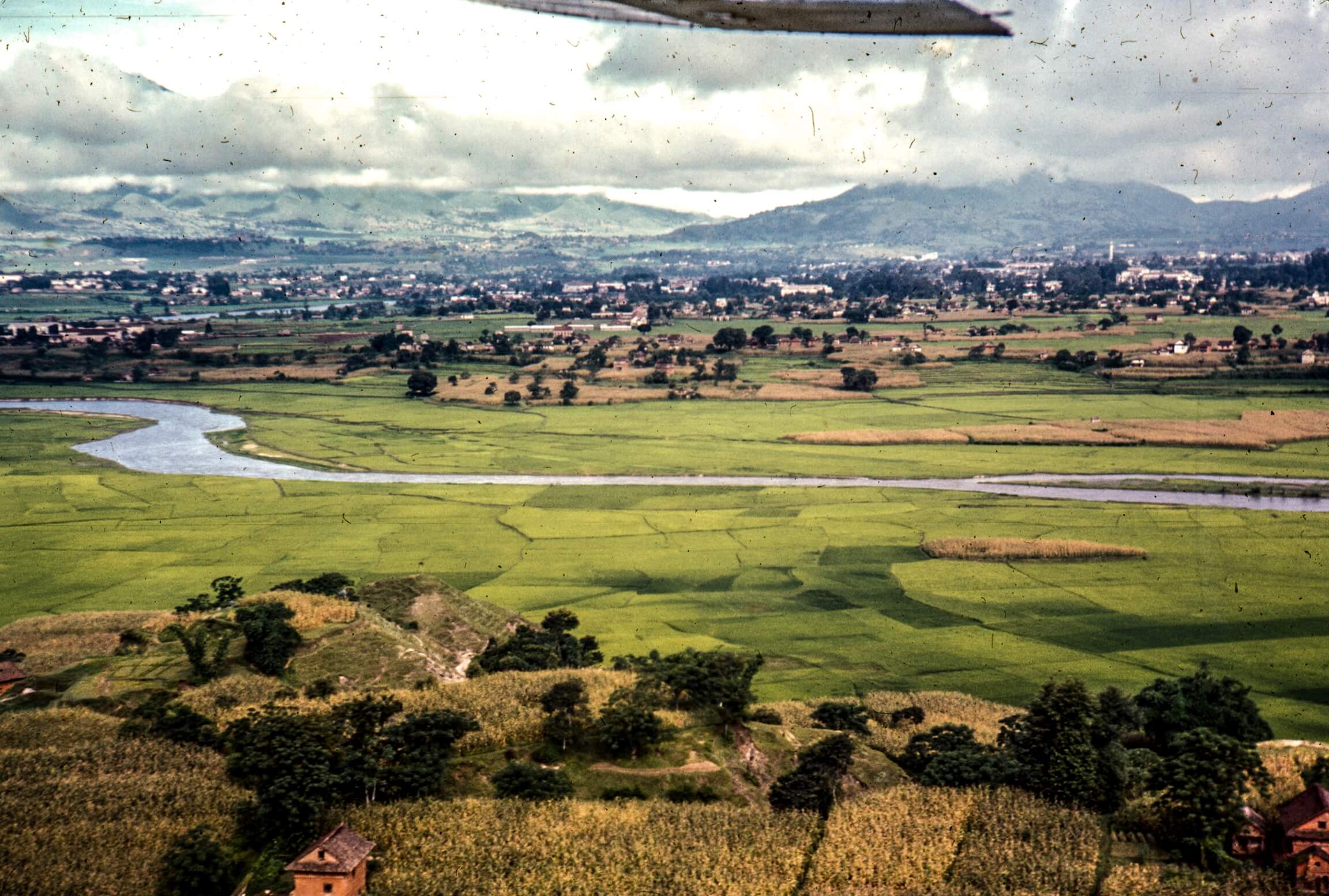
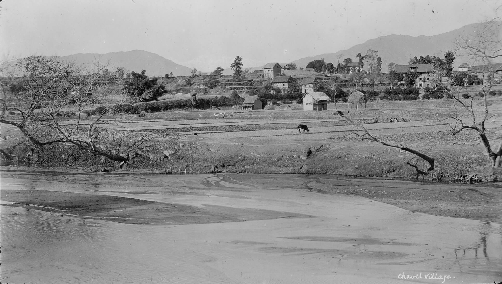
Higher ground meant the apron around the Valley's mountainous walls, but particularly the finger-like plateaus (टार) that stretched from the mountain base to the Valley's centre in between the low-lying waterways. Valley residents built their settlements, including their historic cities, on these tars.
In the 1850s, British physician Henry Ambrose Oldfield noted this pattern: ‘Nearly all the inhabitants of the valley live on the high-level lands. All the cities, towns, principal villages, &c, are situated upon them.’
Valley residents used the lowlands for planting. ‘As a general rule,’ Oldfield continued, ‘all the lowlands of the valley, from their facility of irrigation, and certainty of flooding during the rains, are appropriated to the cultivation of rice ... Here and there a few cottages, or a powa or a temple may be seen upon them, but usually these lands are very thinly inhabited.’ Economic calculus drove this pattern. The ‘extreme fertility and productiveness’ of the lowlands, Oldfield said, ‘cause them to be too valuable to be much used for building purposes’.
And so did health concerns. The ‘lowness and dampness’ of the lowlands ‘make them unhealthy’. But, so did flooding. Oldfield described the ‘certainty of flooding’ because monsoon downpours meant periodic flash floods. Kirkpatrick described these floods a half century earlier.
Increasingly fierce flooding
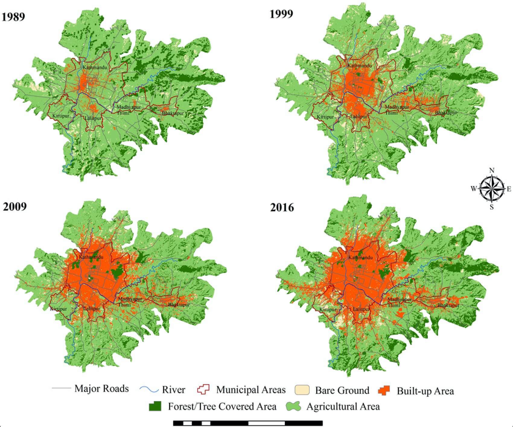
But Kathmandu's 21st century floods differ from what Kirkpatrick and Oldfield described in the 19th century. The situation has changed. Now, it is not just that Valley residents have built where they never used to, on lowlands where floods routinely sweep over. But the environment has also been remade: not just in the floodplains, but the entire landscape, so that the annual floods have grown much worse than before.
Climate change has brought more intense rain. It is part of this new calculus, but only a part. Instead, other widespread changes to the Valley's environment, especially to the water system, have made floods more frequent and fiercer.
Most important, until a couple decades ago, the Valley's soil and sand collected much of the year's monsoon rain soaking it up like a sponge in the summer and releasing it slowly throughout the year. In fact, the ground absorbed and held so much water that the Valley's bigger rivers did not go dry even during the eight dry months of the year. The soil's absorbing power slowed flooding during the monsoon's heavy rains.
"The soil absorbing so much water prevents flooding in the peak season,” water expert Madhukar Upadhya told me. Indeed, historically, the entire water landscape revolved around rainwater's “gradual absorption and gradual release”.
But, Upadhya adds, regretfully, "We have changed everything very dramatically.”
The biggest change is all the big buildings and concrete that block water flowing into the ground. Instead of soaking into the soil, rainwater now hits the roofs and pavement and shoots directly into low areas, filling river beds to the brim, sometimes within minutes.
"We have sealed all the land. Now water goes straight to the खोला (stream), not to and through the ground." Upadhya says. "Water ह्वात्तै आउँछ.”
The problem is not just new buildings in the floodplains. All over the Valley, buildings and roads and courtyards and other ‘impervious surfaces’ block the recharging of groundwater. Once a compact city of bricks and mud, wetlands and ponds, Kathmandu and the entire Valley has become a sprawling metropolis of concrete.
Between 1980 and 2010, Kathmandu quadrupled in area, and is still spreading fast. With heavy in-migration, a more mobile population, and bulldozers carving out roads in every direction, Kathmandu is one of the fastest growing cities in one of the world's fastest urbanising regions.
All this concrete and change has disrupted the Valley's traditional drainage patterns, blocking absorption and accelerating runoff. "The concrete surfaces and the loss of open spaces and wetlands," Ajaya Dixit explains, "have taken away buffers and lead to instantaneous surface runoff when high-intensity rains occur."
Adding to the problem, as Kathmandu grows, is the widespread bulldozing of ढिस्को, the small hillocks of sand that used to dot the Valley's landscape, especially its northern half.
"We have lost sand hillocks at the foothills around the valley that stored rainwater and released it slowly," Upadhya pointed out to me.
Owners sell the sand to go into concrete, then sell the flattened land for houses or other construction. They reap double rewards, but the larger ecosystem suffers. The loss of ढिस्को contributed to the big 2018 floods on Bhaktapur's Hanumante River.
"Before the Hanumante flood lots of hillocks were removed and replaced in the watershed all the way up to Nagarkot," says Upadhya. The floods caused enormous loss. Because of all these changes, Kathmandu Valley water now flows in new patterns. Altering the Valley’s complicated ecological system has brought unintended consequences.
“We No longer have Our Old Rivers"
Just as the Valley's water storage and flow patterns have been completely transformed, so have its riverbeds. Kathmandu's rivers no longer resemble what they used to be.
Sand no longer blankets riverbeds. Waters flows through much narrower channels. Walls on one or both river banks now guide water flow, squeezing the rivers. In places, low banks have been filled, often with rubbish or waste, and built upon. Riverbanks are now walled in and tall.
Where, in generations past, buffalo and goats used to graze and people used to wash, pray, and play, today buildings now sit and cars and motorbikes zoom by at dangerous speeds.
"We don't have the खोला of the past, those are long gone," laments Upadhya.
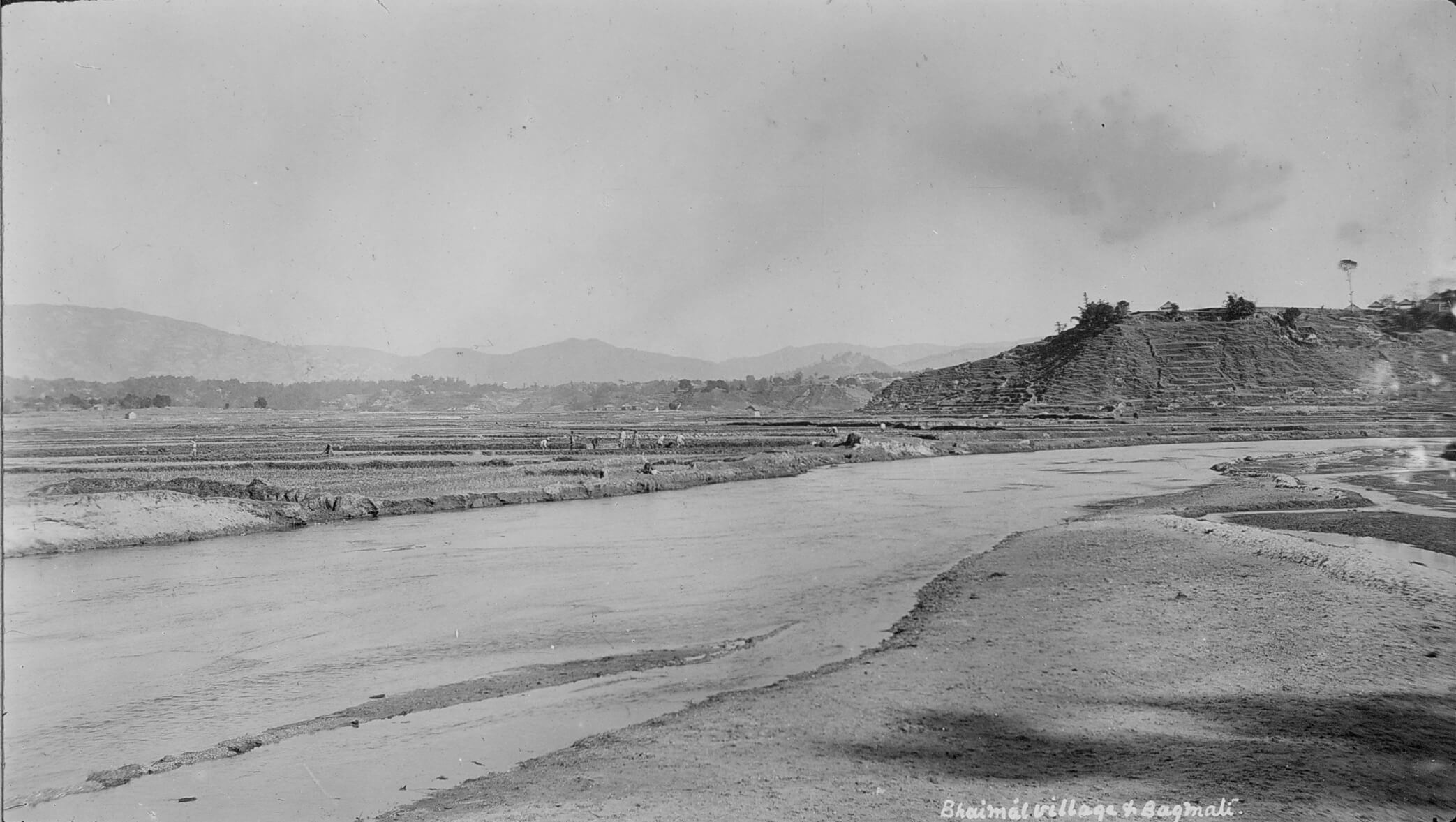
A birder's description of the Bishnumati River from a century and a half ago startled me. "The stream is always shallow, and its channel, though tolerably wide, is for the most part hardly lower than the adjoining cultivated land," wrote a foreign visitor in the 1870s. The Bishnumati 150 years later mostly flows three metres below walls on both sides.
The Bagmati has also become a new river. In the 1870s, the visitor noted that it had ‘a very wide channel’ and the water spread out according to its wishes and needs. ‘Even during the rains,’ he said, the water was shallow, only ‘knee-deep’.
At that time, the Valley's soil still worked as a giant sponge and the river could meander like a grazing buffalo. This was before concrete sealed much of the Valley's soils and river walls squeezed and deepened river currents.
Writing at about the same time, Oldfield also commented on the Bagmati's flow: ‘The Baghmatti is always shallow, but, during the rains, it swells into a wide and rapid stream.’ He also noted that the Bagmati's ‘waters are esteemed to be not only sacred, but peculiarly pure and wholesome’.
Kathmandu's two biggest rivers, the Bishnumati and Bagmati, are now narrowly constrained by stone walls. The sand banks are gone, and they meander less. They are no longer ‘always shallow’.
Big Changes to Small rivers
But perhaps nothing has changed more than the many smaller but powerful rivers such as the Dhobi Khola, the Hanumante, the Samakhusi and even smaller streams. These tributaries and creeks have been covered and sometimes built over. Often, it is hard to tell if the streams even exist -- until heavy rains arrive and fill and overflow the old channel.
Bhaktapur's Hanumante River is less than 20km long. It flows by the lower parts of the city and under the Arniko Highway, the main artery between Kathmandu and Bhaktapur. On 11 July, 2018 heavy rain fell in the catchment area: 129.6mm at the Bhaktapur weather station and 117mm at the Nagarkot station. Soon after midnight, flood waters arrived, cresting for several hours.
The flood’s devastation sprang from several causes. Over the last two decades, the entire watershed has witnessed widespread development. Rain water now shoots directly into the river instead of seeping into the soil.
Scores of sand hillocks that used to soak up and store the water have been removed. In the floodplain itself, whole new housing colonies and scores of businesses have sprung up, mostly along the highway. Garbage and narrow bridges add to the problems, blocking the drainage.
The Hanumante itself is different than it used to be. In 1964 the river stretched 6m across. Today, encroachment means that it is only 2m across. Buildings and other development came up with little heed for the consequences.
‘There were no strong measures implemented by government authorities to mitigate and prevent the flood prior to the Bhaktapur Flood 2018,’ concluded a recent study by the Armed Police Force.
The Hanumante flooding washed away standing crops, and spilled onto the main highway connecting Kathmandu and Bhaktapur, blocking traffic for several hours. Flood waters swept into 500 houses, over 100 shops, 28 small industries including petrol pumps, two schools and two hospitals. In some places, the muddy water stayed for a week.
The police deployed rafts and cranes to rescue hundreds of people. At least three people died, reportedly from landslides upstream triggered by the heavy rain.
The rain near Bhaktapur fell fast the day of the flooding but it was far from record rain. The area had received the same volume of precipitation three previous times. And once, in 1990, well before all the pavement and buildings had come to the Hanumante and Bhaktapur, 250mm of rain fell in a single day, nearly twice what caused the 2018 flooding. Some parts of the mountains near Kathmandu have seen rainfall twice even that amount.
‘We are threatening our own lives by encroaching upon the natural waterway of rivers,’ wrote water activist Rajaram Prajapati in Republica, ‘We are inviting the disaster ourselves.’
Seasonal Streams
Similarly, Kathmanduites have invited flooding by reconfiguring hundreds of the Valley's खहरे, small seasonal streams.
For most of the year, these streams are empty and dry, scarcely noticeable. But when the rains start, they emerge from their out of-the-way corners, flow for a few weeks or a month or two, snaking around the valley, often creating seasonal wetlands, ponds or marshes (known as डोल in Newa), then disappear as the skies clear.
Traditionally, no one built near the खहरे, knowing that in monsoon they would fill with water. But now, as new construction has gobbled up the land, developers cannot resist the terrain through which the streams flow. Predictably, problems have emerged.
Near Boudha, for instance, as Minket Lepcha writes in a wonderful recent long-read article about water and heritage in the Record, the 1990s real estate boom swallowed up several seasonal streams. ‘Fields turned into concrete houses; streams turned into streets; and rivers turned into roads,’ she writes.
People ignore the ecological role of the खहरे. Local resident and environmental lawyer Chiranjibi Bhattarai notes, “In the 1990s, building contractors and real estate owners saw these wetlands as wastelands.”
But nature, Lepcha says, has a way of ‘reclaiming its space’. Almost every year, the Valley's ancient streams and wetlands, even if built up and over with tons of concrete, fill up and flood.
Some floods damage and destroy houses and property. “You trouble the खहरे and the खहरे troubles you,” Bhattarai's son Ayushman points out.
A Missed Opportunity
The big transformation of the Valley's water landscape started in the 1970s and 1980s. Alarmed by the changes to longstanding traditions, some planners warned of the unhappy results. In retrospect, the warnings look like a tragic missed opportunity.
People started putting up buildings, including homes, on the lowlands by the rivers for the first time in the 1970s. Buildings popped up along the Dhobi Khola, Samakhusi, Bishnumati, and Bagmati.
A 1986 Government of Nepal/USAID report observed: ‘It is noteworthy that Kathmandu ... has only recently begun to occupy lower-lying flood plains.’
Perhaps some building was inevitable, the report authors noted. But nonetheless they decried the change, predicting serious problems: ‘As these areas are subject to flooding and high water tables, alternative sites should be encouraged,’ they warned.
Some may blame Kathmandu's environmental problems on explosive population growth. Indeed, the population has increased dramatically, and those people need land and other resources. But this argument is no excuse for bad planning.
The GON/USAID report in 1986 by the Kathmandu Valley Town Planning Office and a team of consultants blamed the government for much of the new riverside development. Noting that new buildings were going up on the right bank of the Bagmati from the Dhobikhola to Teku, it added: ‘Conditions here are nearly as deplorable as they are along the Vishnumati, and responsibility lies squarely with the Government. Facilities established by the Departments of Health and Roads and the Solid Waste Management Board have ruined the potential of this site, once an important socio-cultural and religious area.’
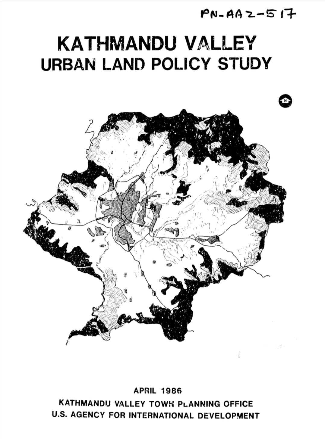
The report called for preserving lowlands for agricultural use along Lalitpur's Bagmati, Khodaky, and Nakhu, and Kathmandu's Bagmati, Vishnumati, Balkhu, and Samakhusi. Flood risk meant buildings should go elsewhere.
‘Not only are these “vegetable belts fertile” but they have high water tables and are poorly-drained. Thus, they are not good sites for urban development ... Problems will surely occur.’
The report called for greenbelts along the rivers: ‘Preserving the flood plains for agriculture will not only avoid costly environmental problems but will also maintain a series of greenbelts throughout the urban area as it expands. If these farmer-tended "open spaces" are not preserved, one can expect...the same sort of environmental damage which has occurred along the Vishnumati.’
The report specifically warned about Gongabu: ‘Expansion on flood plains in Balaju/Gongabun should be controlled. Too much pressure will exist for this area to be fully preserved. It is best suited for non-residential use due to drainage problems.’
Many of the multi-story buildings built in this area since this warning collapsed in the 2015 earthquake, killing many people. Although many factors determine earthquake risk, shock waves generally do more damage in the soft sediments of floodplains than in rock.
Today, after decades of increasingly severe, costly flooding, the 1986 USAID report seems prescient. Sadly, it now seems a missed chance to head in a better direction. What would Kathmandu look like today if even half of these recommendations had been followed?
What Now?
Looking forward, Madhukar Upadhya warns of more intense floods: "We have altered the valley’s hydrology completely. We have already created a ticking time bomb ... The storm water just cannot flow out of the narrowly jacketed river channels without causing harm."
I asked the experts what could and should be done. "One has to go back to the basics of hydrology," Ajaya Dixit said, "and heed to water science in our ways of doing business.”
More specifically he mentioned four things:
- Floods risk reduction is more about drainage than control.
- Rivers must be given space.
- Tools are needed to address extreme events and understand them better.
- Focus should go toward interdisciplinary water education.
Upadhya also called for rethinking the basics: "Broadly, I would say, we need a massive campaign to manage rain water, not boutique activities like building a few ponds and planting some trees.”
Tom Robertson, PhD, is an environmental historian who writes about Kathmandu and Nepali history. His Nepali-language video series on writing, 'Mitho Lekhai', is available on Youtube. His most recent article, 'The monsoon, and nature's arithmetic' appeared in the 26 June edition of Nepali Times.
Prajapati, R.; Raj Thapa, B.; Talchabhadel, R. "What Flooded Bhaktapur?" My Republica, 17 July 2018.
Bhatta, B., & Pandey, R. (2020). "Bhaktapur Urban Flood related Disaster Risk and Strategy after 2018." Journal of APF Command and Staff College, 3(1), 72-89.
Y.P. Dhital and R.B. Kayastha, “Frequency Analysis, Causes and Impacts of Flooding in the Bagmati River Basin, Nepal,” Journal of Flood Risk Management 6 (2013): 257, https://doi.org/10.1111/jfr3.12013.