
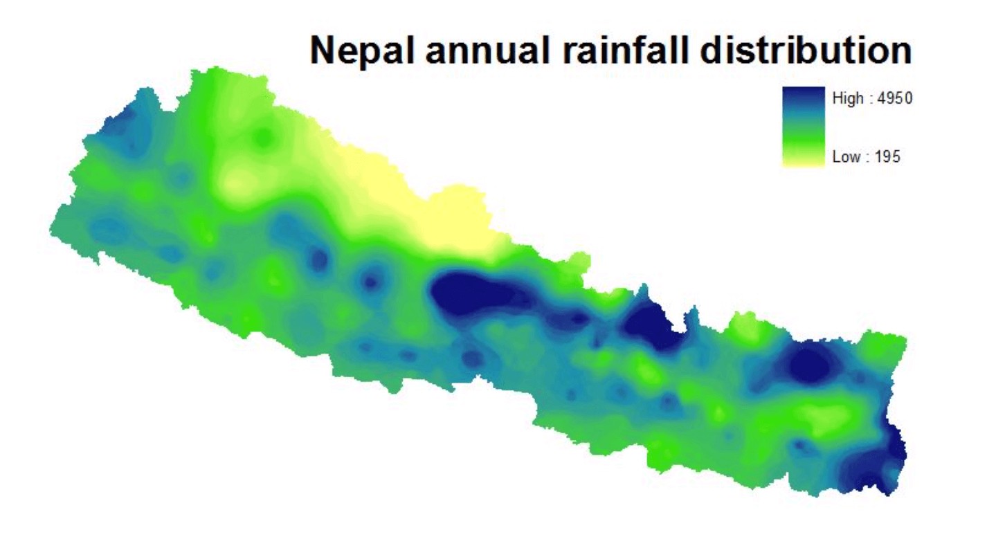
This year’s monsoon rains started early, and have been heavy. But total precipitation for June and the rainfall recorded for the past five days in Central Nepal have not been above normal.
The past week saw a convergence of moisture from both the Arabian Sea and Bay of Bengal branches of the southwest monsoon which did bring isolated heavy rainfall in parts of the central-west mountains and eastern Nepal. Kathmandu Valley saw 70mm of rain between 5-13 July, which is about normal for this time of year.
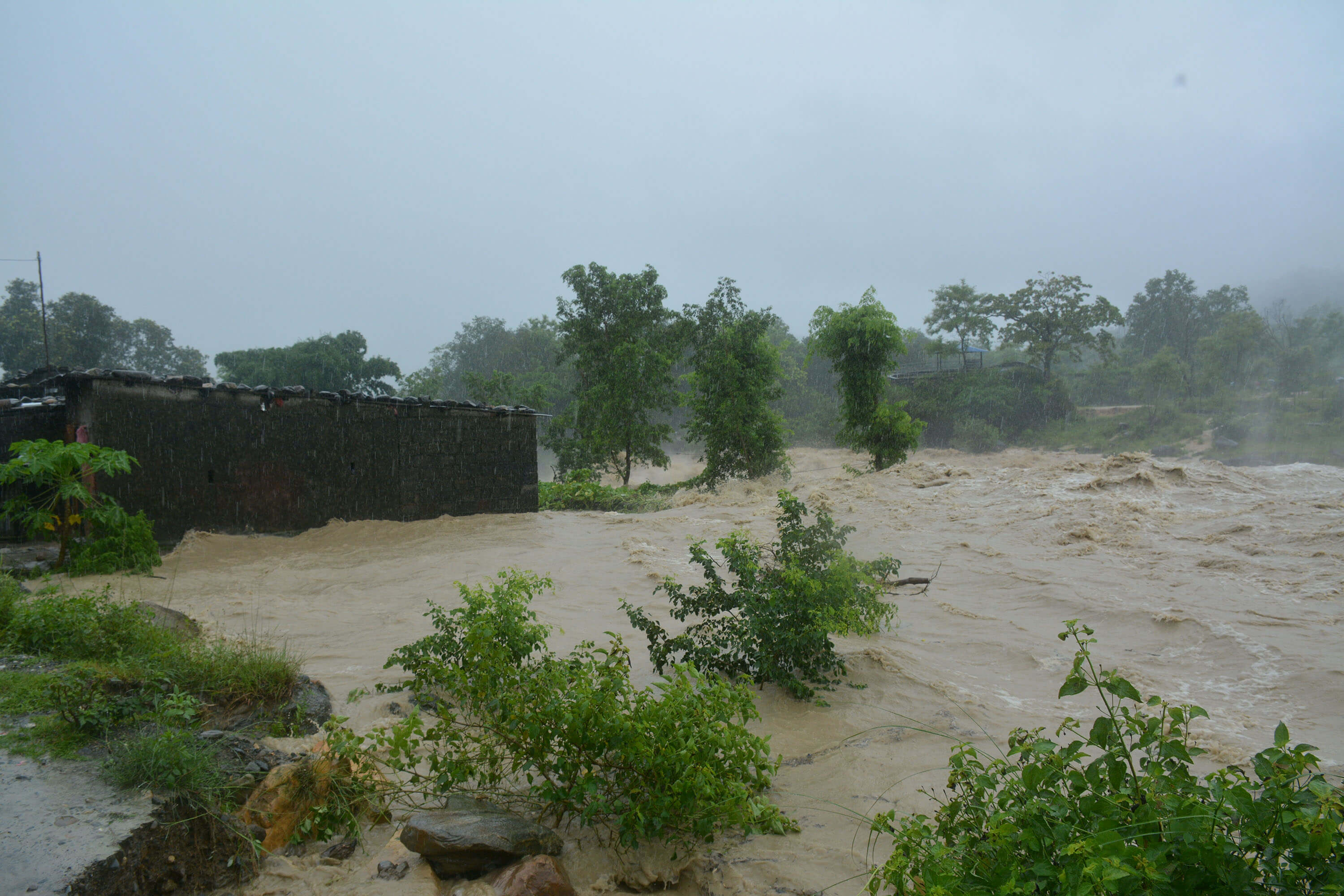
However, disaster management experts say many of the deadly landslides were triggered by haphazard road construction that disturbed the slopes and natural drainage, while in the plains floods have been made worse by poorly designed roads, urbanisation of floodplains, deforestation and sand extraction in the Chure, as well as embankment building across the border in India.
“The rivers all flow down from the Chure, and the soil erosion is raising the level of the river beds making floods damage of the fertile farms of the Tarai worse,” says Nagdev Yadav of the Community Development and Advocacy Forum in Province 2.
Preparing for floods during a lockdown, Diya Rijal
After the 2017 flood, a study by Practical Action concluded: ‘The increased intensity of the flood impact was caused by improper drainage system in cities, cross-border embankment, and elevated roads in borders, causing more inundations in the Tarai.’
Co-author of that study, climate risk expert Madhab Uprety adds that this year saw 30% higher pre-monsoon precipitation in April-May. The top soil on mountain slopes were therefore already saturated when the main monsoons hit, making them more prone to landslides.
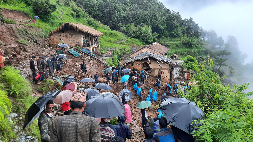
According to the National Disaster Risk Reduction and Management Authority (NDRRMA) there were already 120 major landslides from June 14 to July 8. So far, the death toll is 60 killed and 42 missing with many injured. At least 150 families have been affected by the landslides.
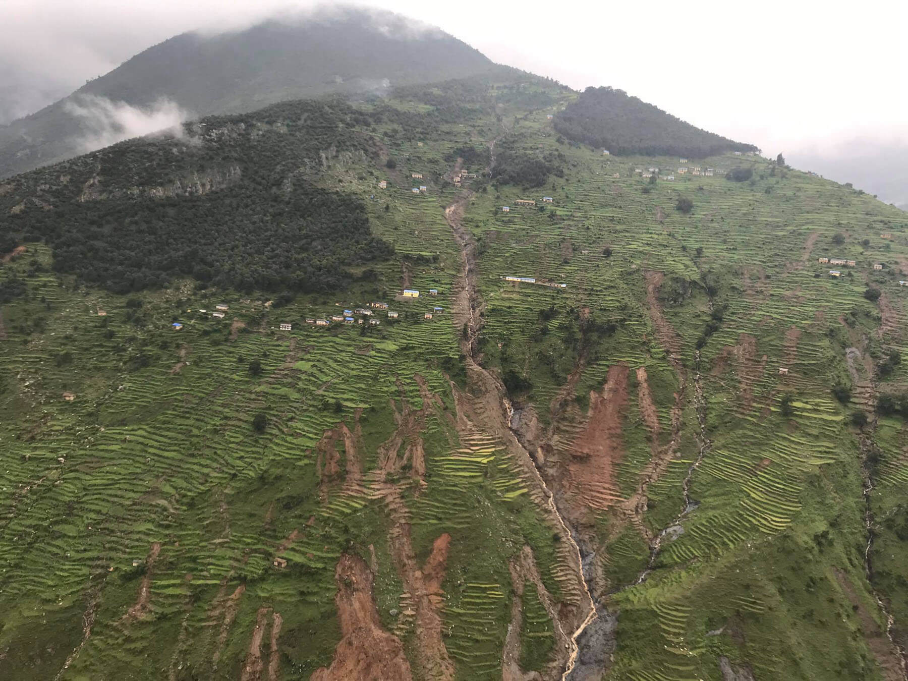
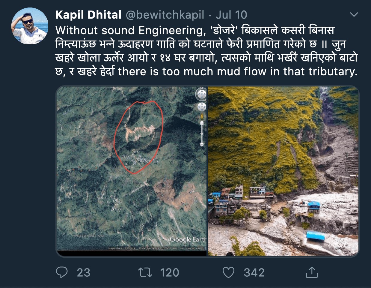
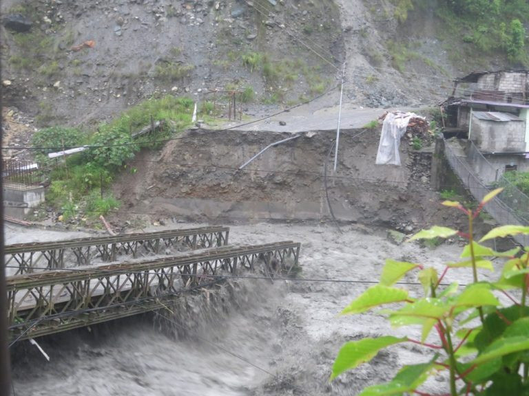
Experts who analysed the deadly flash-flood on two tributaries of the Bhote Kosi on the night of 7 July conclude that a combination of heavy rain and bad engineering on a road up the mountain caused the slope failure.
‘There is a newly-constructed road above the stream that brought down the flashflood that swept away 14 houses,’ tweeted water resource engineer Kapil Dhital. ‘There is too much mud flow on that tributary.’
Indeed, haphazard road construction without inputs from bio-engineers cause rock falls even in the dry season. When the rains come the entire slopes on which the roads are hurried dug by excavators are prone to failure. It is then the settlements and farm terraces below them where people are killed and farms destroyed.
This year’s flood and landslide damage comes on top of the economic hardships caused by the coronavirus crisis. Hundreds of thousands of in-country migrants and workers from overseas have returned to their villages. The floods in the Tarai is predicted to worsen the country’s overall food security situation.
Other reasons for annual floods along the southern borderlands are the unilateral construction of flood control levees, road embankments without proper drainage in the Indian states of Bihar and Uttar Pradesh. Tension between India and Nepal means there is no immediate prospect of negotiations.
It is not just in the plains. The devastating flood in Thimi and Bhaktapur in 2018 was blamed on natural drainage channels being blocked by boundary walls and encroachment on flood plains constricting river flow during the monsoon.
The Department of Hydrology and Meteorology is closely monitoring long-term weather forecasting and rainfall patterns this monsoon. “The trend of heavier-than normal pre-monsoon precipitation looks set to continue for the rest of the rainy season,” explains meteorologist Indira Kandel. This is bound to make flooding and landslides even worse towards the tail end of the monsoon when the topsoil is even more saturated, and the Tarai plains are already waterlogged.
At the NDRRMA, the strategy is to have a proper early warning system in place, using remote sensing satellite weather data, rainfall measurements in the catchment areas, and monitoring of river flow so that settlements downstream have time to move to higher ground and shelters.
A network of community-based early warning systems are also in place to relay the data to villages that are vulnerable to flooding – especially along and downstream from the Chure Hills.
“We have installed instruments for early-warning on the Rato River between Mahottari and Dhanusha so that if the water level rises above the danger mark, the information is passed on to communities lower down, and the police, army and Red Cross alerted,” says Nagdev Yadav, whose organisation is trying to broaden the scope of early-warning to also forecast the impact on farms and crops.
However, despite the early warning network throughout the country through SMS, radio and social media, many people still do not take it seriously. They may also not have anywhere safer to go, and there is no landslide hazard risk mapping for villages in the mountains.
“When people have to evacuate from the warning, they tend to only do it at the last moment when the water has come into their houses, and this causes more death and destruction,” says Madhab Uprety.
On Saturday, the streets of far-west Tarai city of Mahendranagar were flooded. There had been heavy rain, but the inundation was caused more by poor drainage and blocked streams.
“It only rained for one day, but it caused widespread submergence of the streets because of blocked drains, the spread of the city into the floodplains, and the squatter settlements along the rivers,” explains disaster management expert Himalaya Thapa.
Mahakali Municipality in western Nepal was also hit by floods last week, and Mayor Bir Bahadur Sunar says it was not caused by heavy rain but by drainage issues. He says: “The inundation was not due to the overflow of the Mahakali River, but because water was trapped by road construction.”
Another reason for flooding can be extreme weather events. Cloudbursts in which hundreds of mm of rain fall in just a few hours are common along the Himalaya, and can cause flooding and landslides even if rivers are flowing naturally, and there is adequate drainage. There is evidence that cloudburst are getting more frequent, and this has been attributed to climate change.
“The frequency of floods and landslides have increased over the years, and this could be caused by heavy rains, but in 2017 there were devastating floods even though the precipitation was not above normal,” Uprety says, summing up the dilemma. “Embankments made for flood protection but it confines the river and causes more floods. We also do not take into account the sediment load raising river beds.”