
Some 15 million people worldwide are at risk from flooding caused by glacial lakes, half of them in India, China, Pakistan and Peru, according to the latest study published in the journal Nature Communications.
As the most densely populated mountain country in the world, Nepal is at higher risk. Glacial Lake Outburst Floods (GLOFs) in the Nepal Himalaya can be even more catastrophic for towns along valley floors as well as downstream infrastructure.
What happened in Melamchi in July 2021 is a sign of things to come. Nepal’s largest infrastructure project to supply water to Kathmandu was nearly destroyed by a massive debris flow after a cloudburst upstream in the Langtang National Park.
“What make GLOFs worse in Nepal is that they are often combined with the monsoon,” explains watershed expert Madhukar Upadhyay. “Every year we have seasonal floods. When a weakened moraine is breached, more water is added to already swollen rivers. Making matters worse is high-intensity rainfall in higher altitudes as we saw in Manang in 2022.”
Read more: Climate risk to hydropower investment, Ajaya Dixit

Scientists say that the permafrost binding loose moraine material is also melting, and without the cementing action of the ice the moraine walls can collapse easily in heavy precipitation. Rain falling where there used to be snow is making matters worse.
The Himalaya is melting faster than the global average, and even in the best-case scenario, the mountains will lose more than one-third of their ice by 2100.
A paper published in the journal Climate and Atmospheric Science last year revealed that the rate of ice loss on the South Col of Mt Everest is shocking: what took 2,000 years to accumulate is melting in a mere 25 years.
Read also: Tracing past glacial floods in Kanchanjunga, Alton C Byers
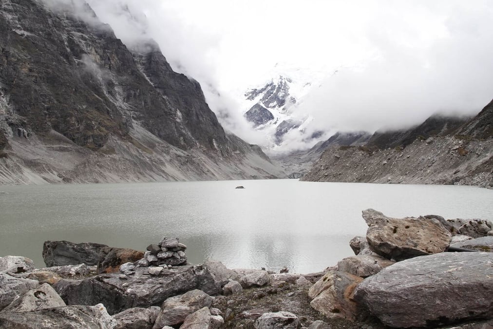
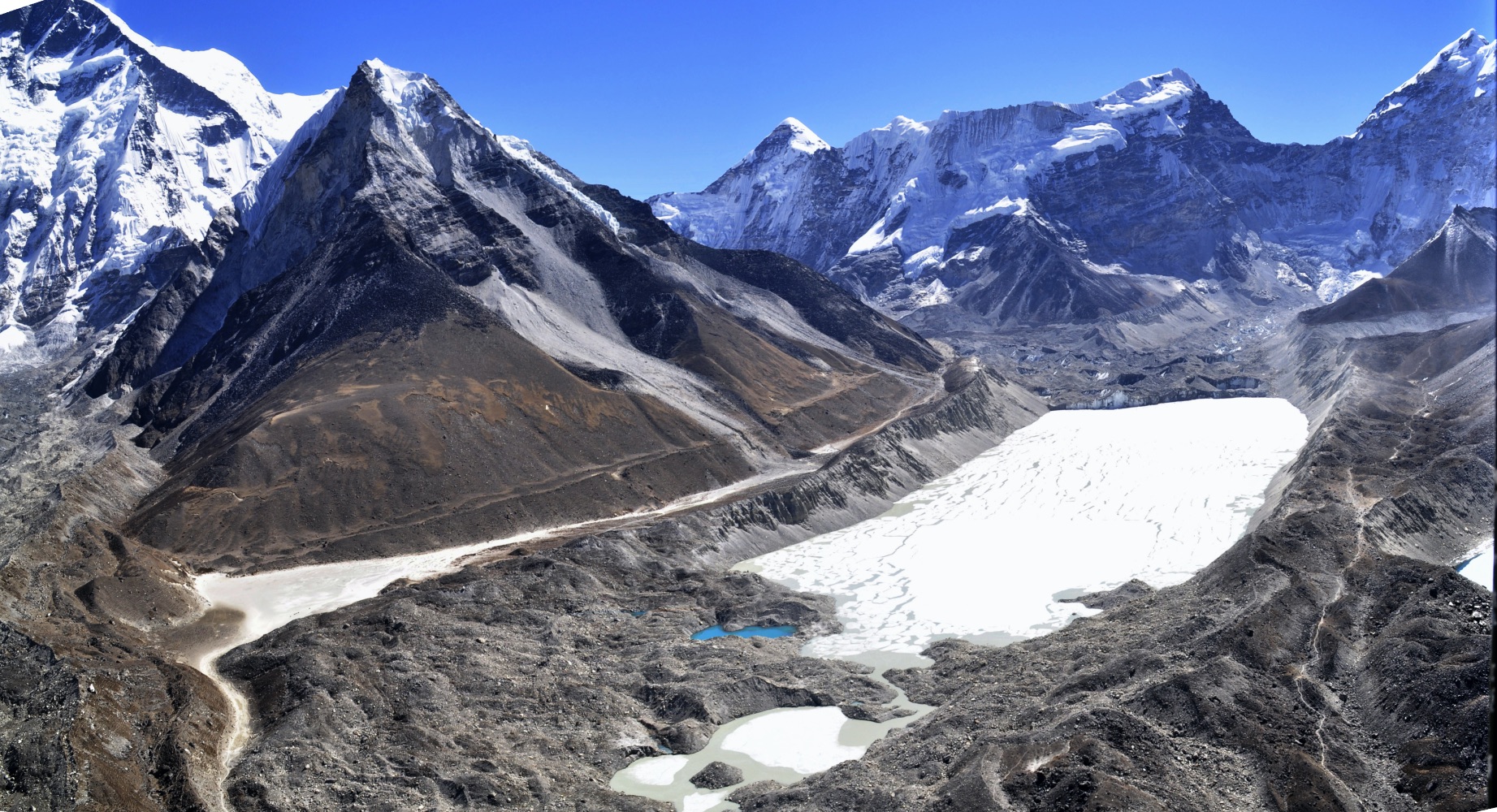
There are 3,252 glacial lakes in Nepal, including the Khumbu Glacier where Base Camp is now 50m lower than when Hillary and Tenzing climbed Everest seventy years ago.
Imja was a debris covered glacier on trekking maps even 25 years ago, but is now a 2km long lake. Tso Rolpa glacial lake at 4,580m in the Rolwaling Valley has grown seven times in size in the past 60 years.
“There is a lot of evidence that the number of glacier lakes in Nepal and worldwide is increasing,” says Miriam Jackson, glaciologist with the International Centre for Integrated Mountain Development (ICIMOD). “The size of existing lakes is also increasing. For example, the area of glacier lakes increased by 12% in the Kosi basin and 8% in the Gandaki basin.”
The water level in Imja has been lowered by 3.4m and by 3m in Tso Rolpa at a cost of $7.2 million and $9 million respectively. Scientists now say the water level in Tso Rolpa needs to go down by another 20m to reduce risk of bursting.
Read also: DANGER: Nepal’s glacial lakes are filling up
There are other potentially dangerous lakes like Thulagi below Himalchuli, and new lakes are emerging on both sides of the Himalaya in China and Nepal that have not even been mapped. Nepal’s glaciers are shrinking three times faster than in 1998 and Jackson says that the possibility of flooding, whether from glacial lakes or other sources, is taken into account when building close to the rivers.
When Nepal’s only reservoir project on the Kulekhani was commissioned in 1982, engineers had designed it to function for 100 years. But a cloudburst in the catchment area in 1993 deposited so much debris into the lake that its lifespan was reduced by 30 years.
“Melamchi and Kulekhani are proof that the entire Himalayan region including Nepal are not suited for mega projects. Our focus and investment should instead be on multiple small-scale projects spread out across the country,” says watershed expert Madhukar Upadhyay. As for infrastructure already under construction, there are several mitigating measures that can be deployed, such as early warning and real-time information systems in the catchment area, not only about rainfall but GLOFs and landslide blocked rivers.
Experts say Nepal and the countries in the Himalaya should not overlook the phenomenon of permafrost melting that is making the mountains and moraines much more prone to erosion. Permafrost is a thick subsurface layer of frozen soil that is generally not visible and thus harder to identify. Besides Melamchi, thawing permafrost is thought to have been partly responsible for the Chamoli disaster in the Indian Himalaya in 2021.
Read also: The day after tomorrow in the Himalaya, Navin Singh Khadka
“Generally, moraines have an ice core, which is one reason why moraine-dammed lakes are so dangerous. The ice could be hundreds or even thousands of years old and melt very slowly but the moraine is constantly settling,” explains Jackson. “Thawing permafrost makes mountains unstable, thus causing rockfalls. If there is a landslide into a glacier lake, then that could trigger a flood.”
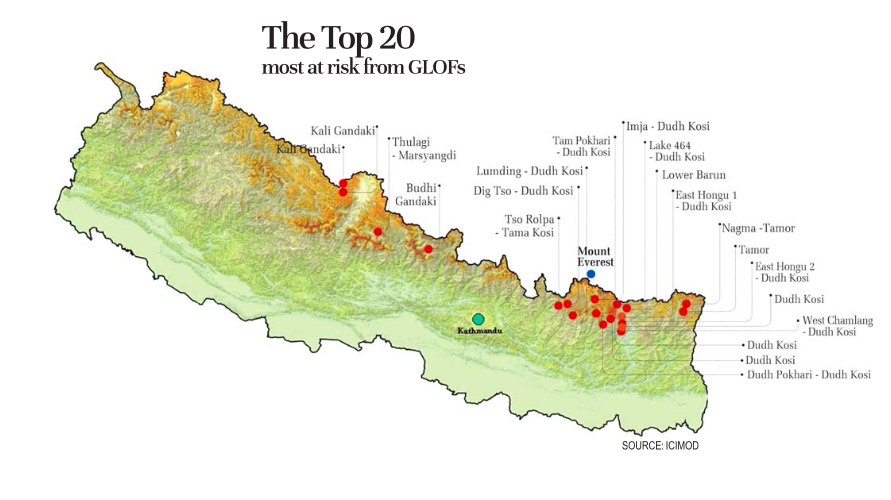
GLOFs also have a transboundary dimension since so many of Nepal’s rivers and their tributaries originate in glaciers in Tibet. Of the 47 high-risk glacial lakes in Nepal, 20 of them start in Tibet (see map, below). Mitigating measures such as artificially lowering the water level are expensive which makes cross-border early warning of GLOFs so crucial. ICIMOD has launched the Kosi Initiative with a transboundary working group collaborating with the Chengdu-based Institute of Mountain Hazards and Environment (IMHE) and others. It has also done computer modelling of flood hazard and an assessment called WeACT that integrates local knowledge with science to improve community preparedness.
But GLOF risk can be reduced if vulnerable communities are aware of the danger, are given decision-making powers and have the resources to be prepared, as has been seen in Chunkung in Khumbu and Langtang, where villagers are adapting to climate change by building embankments on their own, and avoiding construction along river banks.
Says Madhukar Upadhyay: “We need to strengthen our local science to better understand the geology and glaciology, make local communities and the national government aware of the dangers and take the risk into account in building settlements, hydropower plants, bridges and roads.”
Read also: Human face of a Himalayan climate crisis, Rastraraj Bhandari