
DANGER: Nepal’s glacial lakes are filling up
Among all the other disasters we have to be prepared for are glacial lake outburst floods
It is now looking doubtful if countries around the world can cut their greenhouse gas emissions as agreed in Paris six years ago, so that global temperature rise will be limited to 1.5 Celsius by 2050. The earth is going to heat up by more than that.
Even if it is 1.5 Celsius, the average temperature in the Himalaya will go up by 1.8 degrees because of a phenomenon called ‘altitude effect’. The best-case scenario is that one-third of all remaining Himalayan glaciers will have melted during this century. However, if greenhouse gas emissions continue to rise at the present rate, two-thirds of Himalayan ice will be gone by 2100.
All this will have a catastrophic effect on water supply for 1 billion people downstream on rivers that originate in the Himalaya, as well as throw off kilter weather systems. It will also increase the danger of glacial lake outburst floods (GLOF) within Nepal.
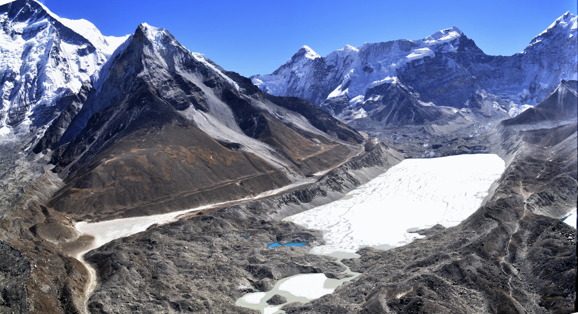
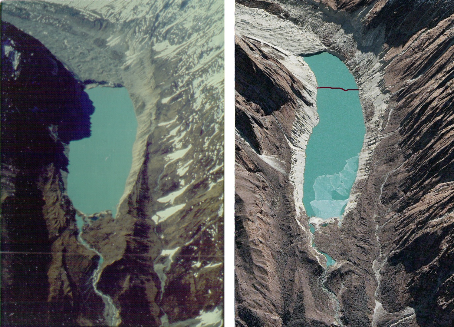
Till the 1960s, the Imja Glacier near Mt Everest had only a few melt-pools. Since then, the ice has been replaced by a lake nearly 2km long, 600m wide and up to 150m deep. The ice is receding 70m a year.
As glacial lakes expand, there is a danger of them bursting due to water pressure, or because of earthquakes and avalanches falling into them. As the average temperature in the mountains rises by 0.056 Celsius every year, the threat of glacial lake outbursts will only grow.
On top of the perennial risk of earthquakes, new hydropower stations, highways along rivers, bridges and towns will also have to take into account the threat of GLOFs. The flash flood near Nanda Devi in India’s Uttarakhand state in March washed away two hydroelectric plants that were under construction.
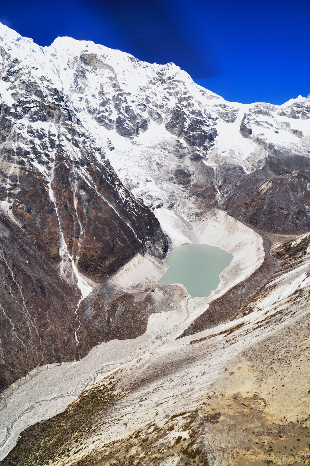
There is a warning there for Nepal, which is building cascade projects on the two Bhote Kosi rivers that flow down from China, Tama Kosi, Marsyangdi, and the Arun. In the Gandaki Basin is the particularly dangerous Thulagi glacial lake below Himalchuli, which would directly threaten three major hydroelectric projects along the Marsyangdi River. Scientists monitoring Thulagi have found the glacier has receded by 2km since 1984, the ice replaced by a lake.
Tracing past glacial floods in Kanchanjunga, Alton C Byers
“If Thulagi were to burst, the flood would go down 100km downstream on the Marsyangdi and Narayani, taking out hydroelectric projects, highways and towns along the way,” says Pradeep Mool, a glacial scientist formerly with ICIMOD.
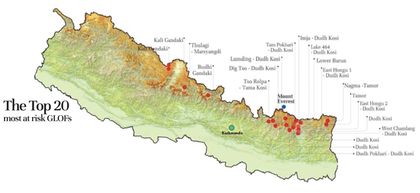
A survey last year showed that GLOF risk is highest in eastern Nepal. There are 42 dangerous lakes on the Kosi basin alone, like Imja, Tso Rolpa, Lower Barun and Hongu. The bursting of any one of these would send a wall of water and debris downstream to the Kosi.
There is also the danger of transboundary GLOFs. In the past, even the bursting of relatively small glacial lakes in Tibet have caused major damage in Nepal. The earliest recorded one was in 1934, when a flash flood from a glacial lake burst in Tibet caused destruction along the Bhote Kosi.
In 1981, another glacial lake burst in China caused a flood on the same river in Nepal, damaging the Sun Kosi power plant and washing out a 25km section of the Arniko Highway, cutting Nepal’s only road to China for three years.
Of the 47 very dangerous lakes that threaten Nepal’s valleys, 25 originate in glaciers in Tibet. Since 1977, there have been at least 20 GLOFs of which 14 were caused by glacial lakes in Nepal bursting, and the rest were in China.
To understand what a GLOF looks like, we have the Seti flood of 2012 which killed nearly 70 people north of Pokhara. Although not caused by a glacial lake burst, it demonstrated the destructive power of such a flood.
Although Nepalis may not be responsible for global heating, it does not mean we can sit back and do nothing. While scientists try to figure out exactly how fast the glaciers are melting, Nepal’s policy-makers need to start planning to be prepared for floods that are bound to be unleashed.
The danger of GLOFs are compounded by Nepal also being on a seismically active zone. Many of these fragile Himalayan glacial lakes could burst simultaneously during a large earthquake.
This calls for hazard mapping, early warning systems through SMS or radio, as well as mitigation efforts like those carried out to reduce water levels on Imja and Tso Rolpa. The microhydro scheme on the Langtang Lirung Glacier that reduces the water level on a recently-formed glacial lake, and also generates electricity could be a model for other remote valleys in Nepal.
Because glacial lakes are located at such high altitudes in remote roadless areas, lowering their water level can be expensive. Most of the equipment has to be flown in by helicopter, and work is often hampered by altitude and weather. The question is: who should pay for these risk-reduction measures?
“Even if the water level is reduced they can burst and come down like tsunamis, we have to keep monitoring the lakes, and install effective early warning systems in Tso Rolpa and Imja to at least save lives if we cannot save the infrastructure,” says Sarju Baidya of the Department of Hydrology and Meteorology.
There are no feasible methods to prevent a glacial lake from bursting, and it is not in our power to stop the lakes expanding. So the only thing Nepal can do is to reduce the level of the most dangerous lakes, design downstream infrastructure taking the dangers into account, and to have an early warning system.
Says Pradeep Mool: “What we can do immediately is to install measurement stations and monitor them by satellite, prioritise the high-risk lakes for site inspections to gauge the strength of the moraines, and make a short list of the most dangerous ones for early warning, and mitigation measures.”
Read also: Human face of a Himalayan climate crisis, Rastraraj Bhandari