
During the 1970s and early 1980s, it was commonly assumed by the development community that the Himalaya was approaching catastrophic levels of environmental degradation, linked primarily to growing human and livestock populations.
Landscapes throughout the mountain world were said to be experiencing unprecedented deforestation, overgrazing, and the terracing of marginal land. In turn, these phenomena were claimed to be responsible for promoting near-crisis levels of fuel-wood shortages, soil erosion, slope instability, geomorphic hazards, and siltation of water courses. Catastrophic consequences were predicted within 20 years, including the loss of all forest cover in Nepal by the year 2000.
Although the origins of the ‘Himalayan Crisis’ models are obscure, the writer Erik Eckholm is usually credited with synthesising the popular and growing concerns of the day in his seminal 1976 book, Losing Ground.
In a chapter aptly titled ‘Refugees from Shangri La’, Eckholm describes the conclusions of a 1974 International Workshop on the Development of Mountain Environment in Munich that warned of ‘…the irretrievable loss to human use of the developing world’s mountain resources—in some cases within one or two decades—unless the present rate of deforestation and land mismanagement can be halted…’.

Although supported by little quantitative or long-term data, a widely accepted paradigm for the international development community was established that became the foundation for dozens of multi-million dollar conservation projects throughout the Himalaya and Hindu Kush region. Especially during the 1980s, these well-meaning projects were typically designed to ‘reverse the trends of environmental degradation’ through tree planting, the introduction of ‘appropriate’ technologies such as improved cook stoves, and better land management.
Challenging the ‘Himalayan Crisis’
However, challenges to this scenario began to emerge by the mid-1980s. Largely initiated by publication of the paper ‘Uncertainty on a Himalayan Scale’, authors Michael Thompson and Michael Warburton questioned the lack of quantitative data and/or case studies in illustration of the negative trends, as well as the reliability of popular figures and statistics being used to illustrate the problem.
By the early 1990s, however, the ‘Himalayan crisis debates’ began losing steam. The programmatic focus of most donors began to shift from government-led natural resource management initiatives, to those emphasising locally-led community forestry, biodiversity conservation, and new protected area programs (climate change would not surface as an issue for another decade).
A wide range of new mountain-oriented organisations and programs emerged as a result of the ‘mountain crisis’ debates, publicity, and impact. They include the establishment of the International Centre for Integrated Mountain Development (ICIMOD) in 1984, the inclusion of mountains within the UN’s 1992 Rio Earth Summit action plan for the 21st century (known as The Mountain Agenda), creation of the Mountain Forum in 1995, and establishment of FAO’s Mountain Partnership in 2002.
In a recent paper on geographical scholarship in Nepal, geographers Elsie Lewiston and Galen Murton also point out that critiques of the ‘Theory of Himalayan Degradation’ in the 1980s may have also paved the way for policies in support of the community forestry programs that emerged in the early 1990s, in addition to a new focus on the value of traditional and indigenous knowledge.
But were the ‘crisis in the mountains’ scenarios really based upon ‘myths, misunderstandings, and misinformation’, as forester Larry Hamilton of the East-West Center maintained? Or could they have been based upon actual fact, or at least triggered by certain social and biophysical conditions that may have existed over 70 years ago?
In retrospect, the answer is that early development practitioners probably had good reasons to be concerned. Although the linkages between ‘farming marginal land’ and increased monsoon river siltation levels were a bit of a stretch, it is hard to believe that the early foreign and Nepal government experts could not recognise a potential problem when they saw one. The more I view Toni Hagen’s films of his journeys through Nepal in the 1950s and 1960s, re-read Harka Gurung’s Landscape Change in the Nepal Hills, or flip through Facebook’s ‘Old Photos of Nepal’ page, the more I see hill slopes with fewer trees, and more land under terraced cultivation than today. There was much less infrastructure, and overall the landscapes look more stressed and less resilient.
In fact, a 2019 study by the East-West Center showed that forest cover in Nepal between 1992-2016 increased from 26% to 45%, based upon the use of comparative Landsat satellite images. A recent Nepali Times article by Peter Gill show this has primarily been the result of Nepal’s community forestry programs, coupled with the massive outmigration since the early 2000s.
With the change to community-based forestry management in the late 1990s, and the growing role of remittances as a source of family income, Nepal’s forests became not only more sustainably managed, but there were also fewer demands upon their resources. Land that was formerly farmed or grazed was now allowed to return to second-growth forest.
However, many scientists believe that Nepal’s commendable increase in tree cover has not been accompanied by an equivalent restoration of biodiversity and forest function. Cardamon plantations have proliferated since the early 2000s, bringing in much-needed income, but at the expense of the removal of much of the sub-tropical forest understory and, as a consequence, wildlife and native plant habitat.
The proliferation of new roads throughout Nepal is now being linked to an unprecedented over-exploitation of rare and medicinal plants because of easier access provided to formerly remote sites, as well as to increases in landslide frequency, slope instability, and river siltation. Lewiston and Murton point out that while ‘outmigration and land abandonment contributed to absolute forest coverage, it has also contributed to declines in soil fertility and increases in invasive species’ that in turn impact biodiversity.
Khumbu’s forests
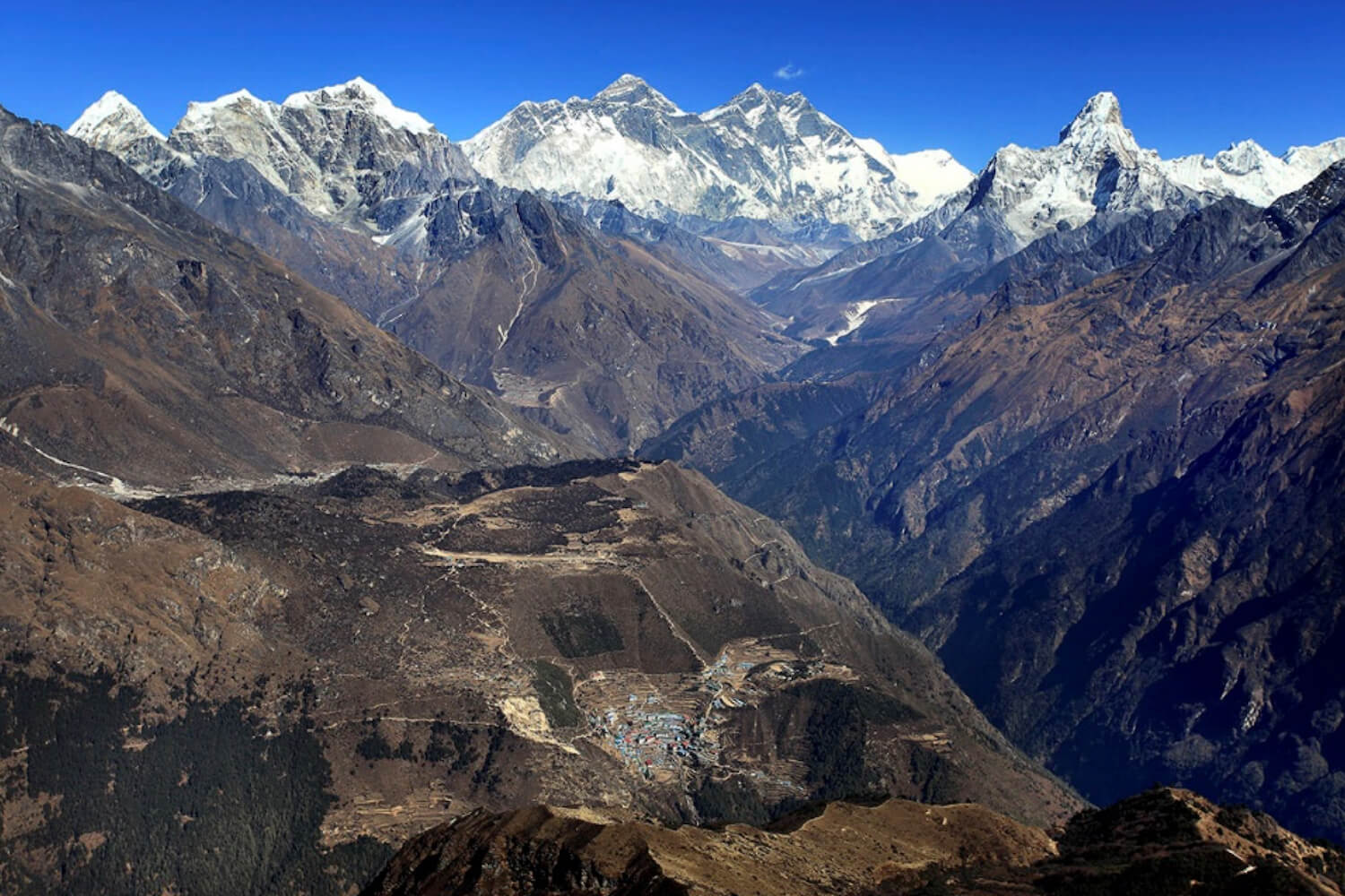
Paralleling the development of the ‘Theory of Himalayan Degradation’, the Sagarmatha (Mt. Everest) National Park in the Khumbu was frequently cited as a representative case study of historical landscape stability, followed by contemporary landscape change and degradation in the High Himalaya.
Historically, this interpretation maintained that major landscape transformations (large-scale conversion from virgin forests and wilderness that the first Sherpa found, to the shrub/grasslands found on most south-facing slopes today) were the result of 500 years of settlement, population growth, and pasture expansion by the ancestors of the Sherpa people; but that ecological stability nevertheless predominated because of the effectiveness of indigenous management systems.
Contemporary issues such as increased forest loss, uncontrolled grazing, and accelerated soil erosion were believed to have been encountered and/or exacerbated only since the late 1950s. Factors of influence, according to most studies, included the imposition of nationalised forest policies in 1957, the consequential breakdown of traditional indigenous management systems, impact of Tibetan refugees who arrived in the early 1960s, misunderstandings associated with the establishment of national parks in the 1970s, the rapid growth of tourism, and various other factors.
In 1984, I spent 10 months in Khumbu as a PhD candidate in geography from the University of Colorado at Boulder, in part to test the credibility of these widely-accepted scenarios of degradation. Based in Khumjung, this gave me and my botanist/geologist wife, Elizabeth, ample opportunity to examine each of the various claims of landscape change and disturbance in some detail.
We talked to people, took detailed measurements, photographs, and sometimes just stared at the forests and mountains in front of us for hours, thinking about change. Several of our conclusions regarding the popular historic and contemporary landscape change and degradation scenarios are described below.
Historical Landscape Change
Were the Sherpas really the first people to inhabit the Imja valley, crossing the Nangpa La (5,806 m) from Tibet some 500 years ago? Did they really find a thickly forested wilderness before them, stretching from today’s Thame to Namche Bazar, Tengboche to treeline at Pangoche? And were they really the ones who cleared the south-facing slopes from Thame to Pangboche of their original forest cover?
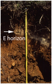
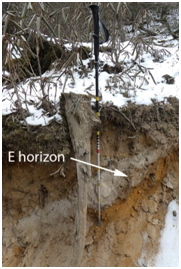
According to the region’s soils, which are capable of telling their own story… probably not. Trail cuts, cattle wallows, and slumps along the trail from Thame to Pangboche do indeed reveal old, buried soil formations that were formed under moist cloud forest conditions, and not the dry shrub-grasslands found today.
Such ‘podzols’ are characterised by a distinctive ‘E’ or grey horizon (Figure 3) that has been leached of its iron and other mineral content from the constant seepage of water. Podzolic soils are still common today within the thick, fir-birch-rhododendron forests surrounding the Tengboche monastery, and can be seen at trail cuts from Tengboche to Debouche.
By identifying the pollen species found in the different soil horizons, collecting and dating the lumps of charcoal found at various depths, and identifying tree species represented by each piece of charcoal, we were able to reconstruct the vegetation history of the Khumbu over the past several thousand years—and the results were surprising.
In brief, the pollen, charcoal, and soil records suggest that moist and closed forest conditions did indeed exist some 2,000 years ago on today’s south-facing shrub-grasslands. These forests became more and more open as the centuries went by, as indicated by increasing abundances of disturbance-loving bracken ferns.
An abundance of charcoal throughout all soil horizons attests to the frequent use of fire as a forest clearing tool. The final conversion from open woodland to shrub-grassland took place between 400 to 800 years ago—meaning that while most books still maintain that the Sherpa were the valley’s first inhabitants, beginning with their migration from Tibet some 500 years ago, our data suggested that people had been visiting and burning the forests on the south-facing slopes of the region for at least 2,000 years, and perhaps as much as 5,000 years ago. Thus, what the original Sherpa settlers saw when they first entered the Bhote Kosi and Imja Valleys was probably not a continuous cover of fir-birch-rhododendron forest throughout the valley, upon both its north- and south-facing slopes.
Rather, what they found was even better—more forest cover than seen today, for sure, but also ample pasture land as a result of a thousand or more years of cutting, burning, and grassland expansion by people living in the valleys directly to the south, quite possibly from the area of Rai settlements such as Bung.
Sherpa oral traditions speak of certain ruins in the Khumbu alpine zone as belonging to ancient Rai livestock herders, and Rai धामी (healers) still travel to Khumbu to find certain medicinal and ritual plants. Over the next several centuries, the Sherpa would make their own modifications to landscapes throughout the entire region to produce the prospects seen today.
Contemporary Landscape Change
And what about the claims of widespread deforestation of the Khumbu’s remaining forests since the 1950s? In addition to the more quantitative methods used in our study, repeat photography provided a valuable qualitative method for better understanding changes in the physical and cultural landscape over time.
The technique itself is simple: find an older photograph of a landscape, glacier, or village. Find the precise photo point used by the original photographer, and replicate it as accurately as possible in terms of identical season, time of day, weather, and camera equipment. If what appear to be changes between the two photo pairs are apparent, ground truth verification is critical to the most accurate understanding of events or processes leading up to that change, usually by establishing sampling plots in the area of question.
Oral testimony from local residents can add tremendous insights to when, why, and how the changes occurred. Literature reviews, especially of older books written by the early scholars, climbers, and scientists to a region, can be an extremely valuable resource as well as a source of additional historic photographs. Time lapse satellite imagery and aerial photography can provide additional insights to more recent changes that have occurred, particularly with phenomena such as receding glaciers, growing glacial lakes, large-scale deforestation, and other major features.
In brief, replication of photographs taken of the Khumbu landscapes by the early climber-scientists of the 1950s suggested that, as opposed to catastrophic levels of land degradation reported in the literature, much of the Khumbu was still well forested, resilient, and rebounding. Landscapes that appear to be ‘degraded’, such as the shrub-grasslands of concern to researchers of the 1970s and 1980s, were in fact highly modified as a result of centuries of grazing and pasture expansion. In at least a dozen repeat photography expeditions to Khumbu between 1984 and 2018, I was able to document a steady return of forest cover throughout much of Khumbu.
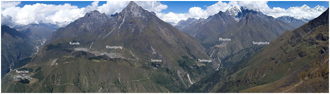
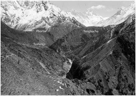
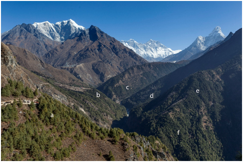
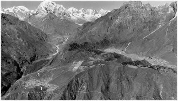
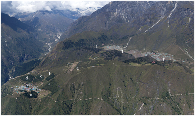
Figure 5 shows a view of Phortse, Tashinga, and the Tengboche hill from the Namche trail in 1956, taken by the Swiss-Canadian glaciologist Fritz Mϋller while on his way to the Khumbu Glacier. Figure 6 shows the same scene again in 2018, where considerable growth of colonizing Pinus wallichiana upon the south-facing slopes to the left, with fir/birch/rhododendron upon the more northerly-facing slopes to the right.
What are the reasons for such a dramatic re-growth in trees, both here and elsewhere in Khumbu? Paralleling Nepal’s experience in general with outmigration and changing lifestyles, Khumbu’s economy today has shifted nearly completely from the agro-pastoralism and trade of the pre-1950s to one based almost entirely upon tourism.
Climbers and scientists were the primary visitors to the region throughout the 1950s, with adventure tourists trickling in starting in the early 1960s. Trekking to the region grew steadily in the decades that followed, from twenty visitors in 1964, 5,000 per year in 1980, to 20,000 per year in 2000. Annual numbers ebbed and flowed through the decades depending upon national and international events, dropping dramatically during the Maoist insurgency (1996-2006), after the Palace Massacre (2001), and following the 2015 earthquake. But they rebounded within a year or two afterwards.
Tourist numbers reached a remarkable 60,000 per year in 2019 (not including support staff, which easily doubles the total) dropping to nearly zero as a result of the Covid-19 pandemic from March of 2020. The Khumbu is waiting out the pandemic, making repairs and buying supplies in anticipation of a post-vaccine return of tourism in 2021 or 2022.
Diets and lifestyles have also changed considerably in the past two decades as the result of easily available imported foods. Likewise, the use of dairy and other products from yak and yak/cattle crossbreed herds is decreasing as more convenient and imported milk, cheese, and synthetic materials become readily available. While yaks and crossbreeds continue to be used as pack animals from Namche to the Everest Base Camp, their numbers are far fewer than they were a generation ago and, as a result, their pressures upon the landscape have decreased as well.
The Sherpa have long practiced an effective system of communal natural resource management characterised by the designation of shingo nawa, or forest guards, within each community. Geographer Stan Stevens, author of Claiming the High Ground, believes that these indigenous and historic conservation ethics were not as negatively impacted by the nationalisation of forests in 1957 as some scholars would believe, which could explain another reason why forests have rebounded in Khumbu.
At the same time, the forest management regulations imposed by the Sagarmatha National Park, starting with the park’s creation in 1976, have likely had beneficial impacts as well. Forester Nick Ledgard, who supervised the Himalayan Trust nursery and plantation projects in Khumbu for over 30 years, believes that fire suppression, as a result of decreased livestock populations and annual pasture burning, may also have contributed to the rapid rebound of forests.
Since 1981, active forest regeneration programs have been conducted by the Park, the New Zealand government and local communities which has led to a significant increase in forest coverage. Hundreds of thousands of fir, juniper, pine, and other native species have been raised in nurseries located throughout the park, and then planted in exclosures in the vicinity of major villages. Forty-five sites totaling some 165 hectares have been planted since 1981. Figures 10-13 trace the establishment and growth of tree plantations near Namche Bazar.
Climate change, warmer temperatures and increasing rainfall in Khumbu, may have facilitated more rapid tree growth. In fact, recent studies demonstrate how with increased temperatures and ascending snowlines, alpine vegetation is expanding upward to higher altitudes. Treelines, the interface between subalpine forest and alpine ecosystems, are also ascending to higher altitudes as a result of warming temperatures and decrease in cattle pressures. And glacial deposits newly exposed by melting ice are now being colonized by alpine wildflowers.
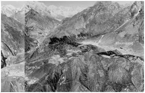
So, were the statements of an environmental crisis in Khumbu in the 1970s wrong? Several of the claims made at the time were clearly overstated: von Fürer-Haimendorf’s observation that ‘…whole hillsides [above Namche Bazar] which were densely forested in 1957 are now [1975] bare of tree growth…’ is simply not supported by photographic evidence. Figure 7 shows that there were no ‘forested hillsides above Namche Bazar’ in 1956.
My own soil erosion research found that while many hill slopes may look ‘degraded’ and ‘erodible’, they are in fact quite stable in a geomorphic since thanks to the soil binding quality of the local shrubs and vegetation.
But in general, the physical and social scientists who visited Khumbu in the 1950s through the 1970s were there at a time when things were far different than they are today. Landscapes at the time were under much more stress than they are today, where tourism has steadily replaced much of the previously agro-pastoral pressures.
How Khumbu now deals with the relatively new and rapidly expanding problems of solid and human waste management, freshwater contamination, and overcrowding, all directly linked to the growth in tourism, remains to be seen. But after 500 years of regularly adapting to changing political, economic, and environmental trends, I am sure that they will figure it out.
Alton C Byers, PhD is a Senior Research Associate and Faculty at the Institute of Arctic and Alpine Research (INSTAAR), University of Colorado at Boulder. His first visit to Khumbu was in 1973 as an undergraduate student of geography. This Longread is adapted from Khumbu Since 1950 (second edition) by Alton C. Byers and Lhakpa Sonam Sherpa, forthcoming in 2021.