
A modified political map of India has created an uproar in Nepal, with street demonstrations and debates in Parliament. Nepalis appear to be genuinely concerned about sovereignty and territorial integrity of their country, and have accused politicians of not defending the national interest.
The politicians themselves have been making statements – some stronger than others – to take up the matter with New Delhi. The Kalapani issue has united Nepal’s political parties to a common cause.
Read also:
Territorialism, Editorial
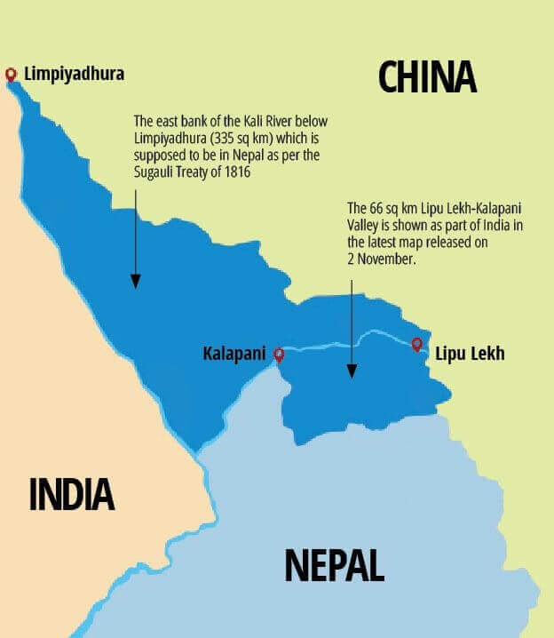
There is also agreement across party lines about the status quo of the boundaries of Nepal as depicted in the 1816 Sugauli Treaty marking the Mahakali River and its source at Limpiyadhura as Nepal’s western border.
Nepal’s leaders are well aware that the Indian troops who stationed at Kalapani since the 1962 Indo-China war on a temporary basis are still there. The reason this issue has flared up now is because of the new map India released last month after Kashmir was politically reformatted.
Nepal shares a 1,808km open border with India, most of it along the southern Tarai plains, and with the eastern and western boundaries stretching northwards across the mountains to tri-junctions with China. Nepal should make a new concerted effort to resolve disputes over Kalapani-Limpiyadhura, as well as along Susta, Narayani and the Mechi riverine borders.
Nepal’s politicians should urgently take up these disputes with the Indian government through high-level political and diplomatic channels. There should also be set up a team comprising of technical and legal experts who are well-versed in laws regarding international boundaries. The Nepal government should seriously propose a timeline to conclude these border dispute talks, and it should look for outside help only if bilateral negotiations prove indecisive and unnecessarily protracted.
One such is the International Court of Justice (ICJ) is an un-biased organisation that gives judgments based on historical facts which can be derived from maps, treaties, documents and memorandums of understanding between two governments.
Boundary maintenance and restoration play an important role in conflict prevention contribute to long-term boundary stability. The Government of Nepal, therefore, should establish well-funded national and international boundary commissions to solve pending post-federalism issues.
It is important to establish map libraries and archives of treaties, historical documents, individual and mutual maps of treaties, aerial photographs, satellite imagery, articles by border experts (geodesists, cartographers, mapping experts and geographers), politicians and lawyers so that they can be studied before we send in delegations at the international and national levels for negotiations of international or state boundaries.
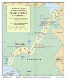
A case study of the Nigeria-Cameroon boundary dispute in which this correspondent was involved has some lessons for the Nepal-India border issue as well. Nigeria and Cameroon share a 1,950km border (960 km on land and 990km of river boundary) starting from Lake Chad in the north to the Bight of Biafra in the east of the Gulf of Guinea.
The two countries nearly went to war over the dispute, but are now engaged in the peaceful implementation of a 2002 International Court of Justice (ICJ) Judgment regarding the land and maritime boundaries, and established a Mixed Commission which holds regular meetings in each other’s capitals under the auspices of the United Nations to implement the agreement. So far, the Mixed Commission has agreed on a timetable for the withdrawal of forces, the transfer of authority, the cost of demarcation .
An agreement signed in 2006 in New York by presidents of Cameroon and Nigeria, the UN Secretary General and representatives of five witness countries (France, Germany, United Kingdom and the United States) led to the return of 80% of the peninsula to Cameroon with full withdrawal of Nigerian troops. The remaining 20% was handed over to Cameroon in June 2010. All four sections of the ruling on Lake Chad, the land boundary, Bakassi peninsula and maritime boundar, have now been implemented peacefully.
Alongside these more high profile legal and political issues, the process of demarcating the land boundary has continued with the Mixed Commission establishing a Sub-Commission on Demarcation with experts from the UN, Cameroon and Nigeria. More than 130 preliminary map sheets of 1:50,000 scale were prepared from partially rectified SPOT5 satellite imagery by the United Nations Cartographic section based in New York.
The Nigeria-Cameroon border agreement shows that if there is political will, even the most protracted and bitter border disputes can be peacefully resolved.
Prabhakar Sharma is a Nepali expert on international boundaries, and worked as a survey engineer for the Cameroon-Nigeria border demarcation by the United Nations.