


Kathmandu loses its open spaces

The tragic death tolls from two recent earthquakes in the Greater Himalaya should give Kathmandu residents pause. Kashmir, 2005: more than 73,000. Sichuan, 2008: over 88,000.
In urban earthquake emergencies, few things are more critical than open space, but Kathmandu Valley has more people and less usable open space than ever before.
A 2020 International Organisation for Migration (IOM) report warns that many of Kathmandu's crucial disaster evacuation spaces have been ‘reduced, encroached, transformed into non-usable areas or heavily built up’, and says the Valley will suffer ‘extreme difficulties’ in the next big earthquake.
‘Open spaces have not been recognised as vital city infrastructures that can be of great significance during a disaster," the IOM report says. History has actually shown the importance of Kathmandu's open space time and again.

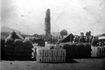
1934
In the afternoon of 15 January 1934, a 8.1 magnitude earthquake shook Nepal and north India. The British surgeon Lt-Col C H Smith described that day's devastation:
‘The city itself was a dreadful sight. At least one house in five had completely collapsed and very few seemed to have escaped uninjured...every hundred yards or so the narrow streets were blocked with piles of debris twenty feet high over which we had to climb.’
Residents, he noted, fled to Kathmandu's open spaces:
‘The inhabitants were behaving splendidly; there seemed to be no panic. The people were all hurrying out of the narrow streets towards the various open squares with what goods and cattles they had been able to save, and were settling down in family groups in these open spaces preparing to pass the night as best they could.’
The next day Smith found people ‘all collected in the various squares and open spaces. They were quiet and orderly, sitting in family groups cooking what food they had. They had no shelter, and must have spent a very unpleasant night, as there was a heavy ground frost.’
Kathmandu was lucky in one respect, Smith said. Had the earthquake hit at night or early morning, when people are generally indoors, collapsing building would have taken many more lives.

Traditionally, Kathmandu residents use many types of open spaces: streets, courtyards (bahal/ bahil), neighborhood squares (nani/chuka), palace squares, and open space at town periphery (khyo, buffer zone).
These communal open spaces were used as living rooms and work spaces (not for motorcycle parking). The people dried grain, washed clothes, and looked after children at play. But during disasters, they turned to these spaces for safety and shelter. Open space created resilience.
At the time, Kathmandu Valley had a tenth of today’s population. People had no problem finding open places to run to.
The city's massive growth was decades in the future. Rani Pokhari, British journalist Perceval Landon noted in the 1920s, stood outside the city. The Ashoka Stupa loomed ‘a mile outside the city of Patan in the country’. Boudha sat ‘among the maize fields’. Budhanilkantha was a ‘long journey out’. Times have changed.
In 1930, approximately 250,000 people lived in Kathmandu Valley. Today there are nearly 4,000,000 people. After almost a century of hurried, haphazard, rule-flaunting development, life-saving open spaces have been ignored and are now much harder to find.
The IOM report reminds us: ‘Open spaces are taken for granted until the need arrives.’
2015
During the April 2015 Gorkha Earthquake, Valley residents once again turned to the city's open spaces. Thousands of families moved into large open spaces such as the Tundikhel. The parade ground also served as a debris management site.

Similarly, Narayan Chaur became a temporary home for 7,000 people. Five days after the first big quake, 33 open spaces provided refuge to almost 31,000 residents of Kathmandu from 5,500 households.
City planners and local activists deserve applause for Narayan Chaur. One of the 83 emergency evacuation sites identified in 2013, it was developed to be multipurpose: as a green public park, a playground for children, and as an emergency shelter in disasters. It pioneered the use of Community Level Search and Rescue (CLSAR) Boxes, containing hammers, rope, saw and many more rescue materials.
Open spaces like Tundikhel and Narayan Chaur brought neighbouring families together, saving lives and reviving community bonds. Kathmandu residents also relied upon open spaces as small as highway medians. After an earthquake, all open space counts.


In 2013, government planners identified 83 open spaces for evacuation and refuge during disasters. According to the 2020 IOM report, only about half of these sites are actually usable in an emergency. New small buildings, storage areas, and infrastructure expansion have eaten into important space. Ten sites have been dropped from the list as they now serve other purposes.
The report highlights other problems: an almost total lack of on-site water and sanitation facilities, unsuitable terrain, scarce local participation, especially of marginalised groups; low public awareness; and insufficient routine emergency drills. Some local governments did not even realise that spaces under their jurisdiction are designated earthquake evacuation sites.
We also need to plan for multiple hazards: earthquake and floods at the same time, or even simultaneous earthquake, flood, and pandemic. Nepal ranks eleventh and thirtieth worldwide in earthquake and flood vulnerability.
This multiple hazard preparedness scenario is not impossible. After the 2015 earthquake, people in Bhaktapur's shelter camps had to flee the gushing Hanumante River.
We often call earthquakes ‘natural’ disasters. Doing so allows governments and others to avoid blame. But the real cause of many disasters is not nature, it is poor human planning. Kathmandu Valley residents would do well to remember how they have relied up open space in the past and will need it again in the future.
The World Health Organisation recommends 9 sq m of open space per person. Kathmandu has about 0.25 sq m per person. Lalitpur has only 0.06 sq m per person, with poorer people’s access even less. So, neighbourhoods with the least open spaces have to be prioritised. Regular drills are needed everywhere so people know where to go and what to do in a crisis.
Says Anil Pokhrel of the National Risk Reduction and Management Authority, “Nepal is one of the fastest urbanising countries in the world, and 2015 was an eye opener. Government had done some work, but it really showed us the meaning of open space.”
He stresses the importance of gardens and parking areas, not just the 83 designated open spaces in the Valley. “We need spaces closer to home,” he adds. “We have serious threats to urban space, such as construction and encroachments, but we also have communities like Thimi that are protecting and restoring ponds and cultural heritage as open spaces for emergencies.”
Pokhrel says the aftermath of the earthquake six years ago showed how crucial water and toilets are for families. He adds, "Our message to every local government is this: work disaster planning into everything you do."


Nilima Thapa Shrestha is an architect and urban planner focused on urban ecological planning and DRR.
Tom Robertson, PhD, is an environmental historian who writes about Kathmandu and Nepali history.