
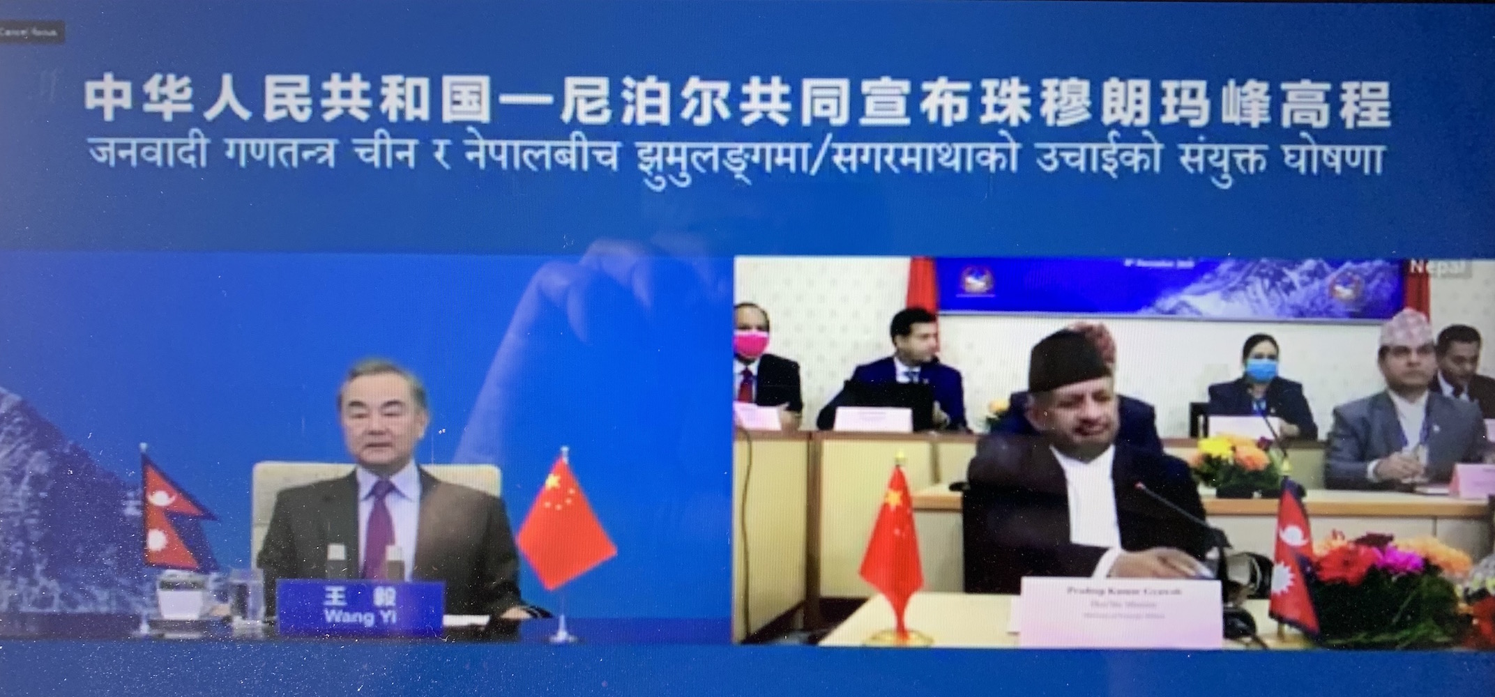
The height of Mt Everest has grown by 86cm to now measure 8848.86m, the foreign ministers of Nepal and China revealed at a joint virtual live event on Tuesday.
The new measurement of Sagarmatha-Zhumulangma (Mt Everest) was declared by Nepal’s Foreign Minister Pradeep Gyawali in Kathmandu and his Chinese counterpart Wang Yi in Beijing by pressing a crystal ball simultanesouly. The two also exchanged congratulatory messages from Nepali President Bidya Devi Bhandari and Chinese President Xi Jinping to each other.
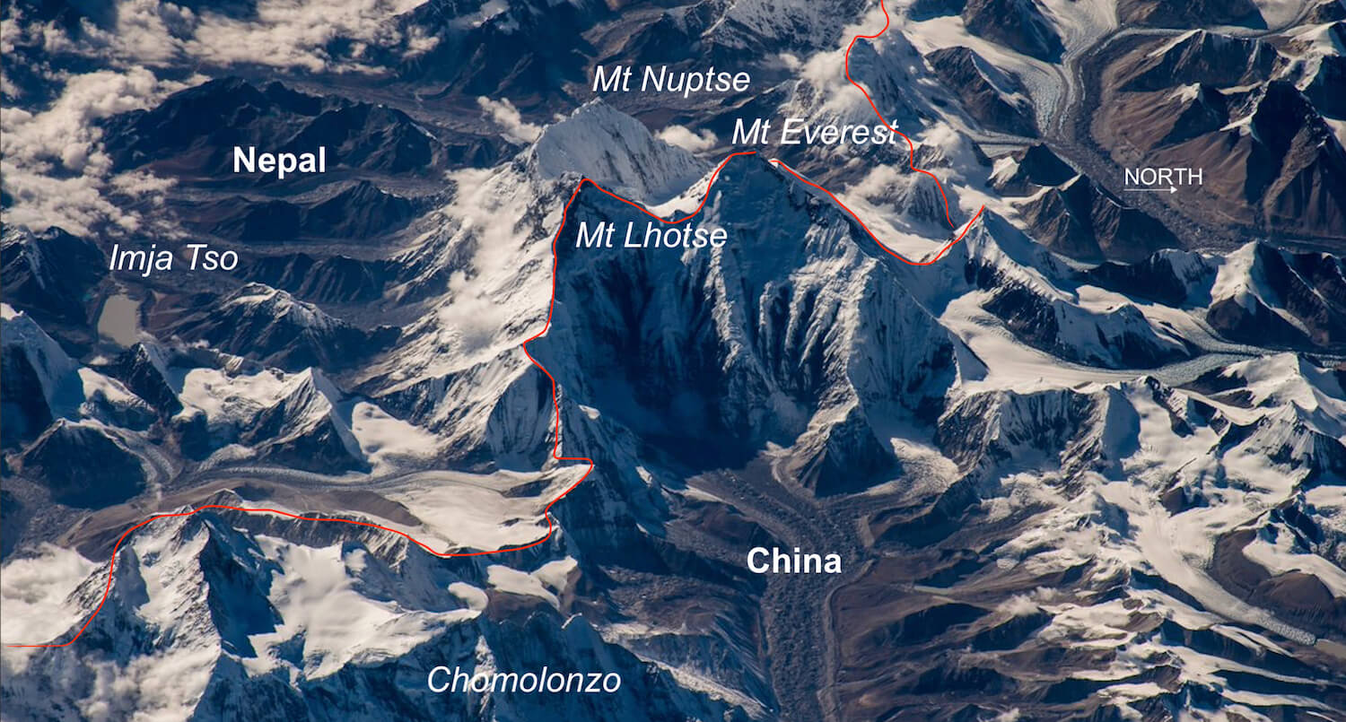
The new height puts end to speculation about whether Mt Everest had risen or shrunk and by how much after the 2015 earthquake, or if there would be a wide discrepancy between measurements by Chinese and Nepali surveyors.
Mt Everest from both sides, now, Raunab Singh Khatri and Rastraraj Bhandari
The announcement came three days before International Mountain Day 2020 on 11 December, and in the week when China’s Chang’e 5 lunar probe is starting its return to Earth with soil samples from the Moon’s surface.
Mt Everest’s elevation of 8,848m (29,028ft) had been accepted since 1955. But depending on who is counting, the height has been plus-minus a dozen or so metres since then.
The joint announcement of the latest measurement of the world’s highest mountain was delayed by the Covid-19 pandemic, and officials in both countries guarded the new number as if it was a military secret.
In the past century and half, the height measurement has changed as more accurate survey techniques became available.
When the Great Trigonometric Survey Of India was done in 1856, surveyors triangulating from the plains found the height to be exactly 29,000ft. However, Sir George Everest, who headed the Survey, thought people would think they rounded off the figure, and added 2ft to it just so it sounded more accurate.
The true height differ depending on where it is measured from – mean sea level, or the centre of the Earth. Because of the Earth’s equatorial bulge, Andean peaks can actually be considered ‘higher’ than Mt Everest.
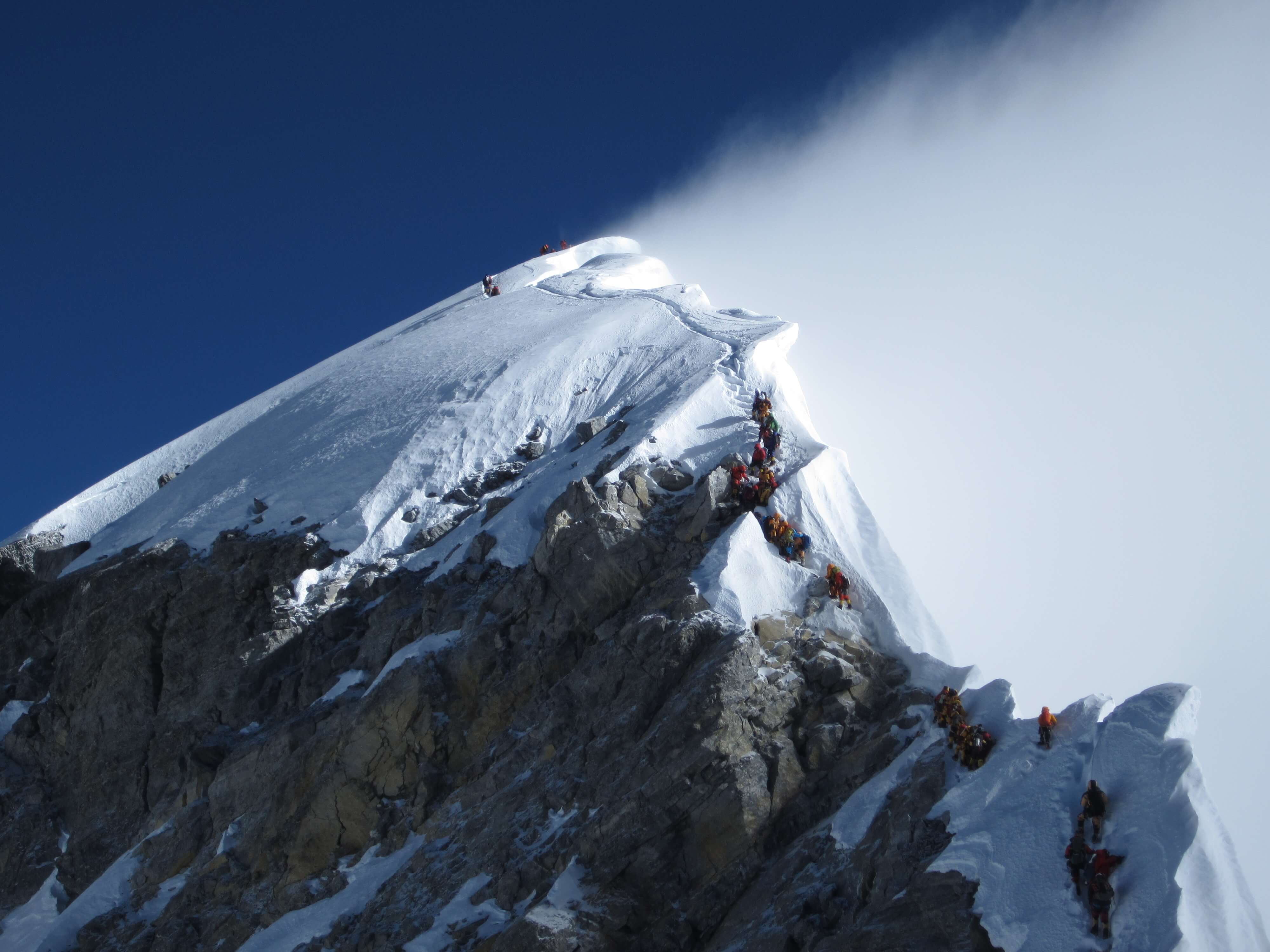
Measurements have also differed in the past because some take the elevation of the rock at the summit, while others also add the icing on top. The snow cornices on the peak are about 4m thick, depending on the season, wind patterns, and the impact of global warming.
Global heating melts mountains, Nepali Times
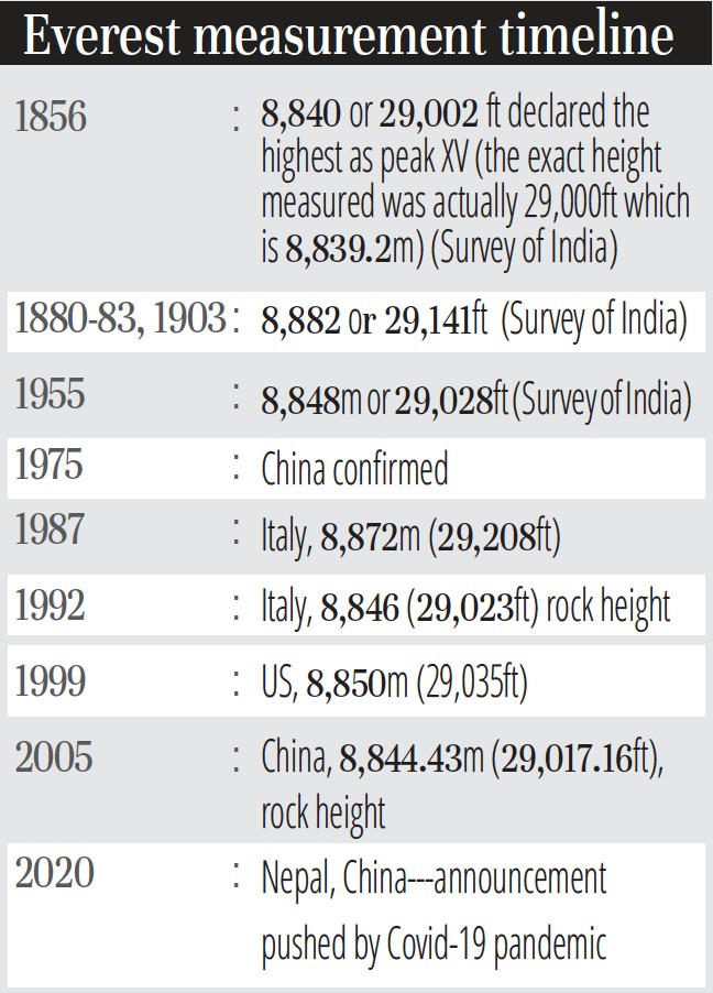
To make it even more complicated, the real height of Himalayan peaks are not constant. There is tectonic pressure which can push mountains up or down, depending on the location. Mt Everest is said to be rising by about 1cm a year, but that is possibly cancelled out by the weathering process.
More recently, geologists and scientists had also come up with different views on the impact of the 2015 earthquake, which is why the new joint measurement was needed. Besides the height, surveyors were also keen to find out if the mountain had moved southwards, and by how much. But the joint announcement on Tuesday did not disclose horizontal displacement.
“The height of Everest is constantly changing due to tectonic activity, of which the 2015 Gorkha Earthquake is only the most recent contribution,” Christopher Pearson of the University of Otago in New Zealand, who worked with Nepal surveyors on the measurement in 2018, explained to Nepali Times earlier this year. “Since the present measurements are fairly old, we needed to update it.”
The New Zealand government assisted Nepal’s Survey Department expedition to Mt Everest in May 2019 with the Global Navigation Satellite System (GNSS), and trained technicians in processing the geodesy, levelling and gravity measurement data.
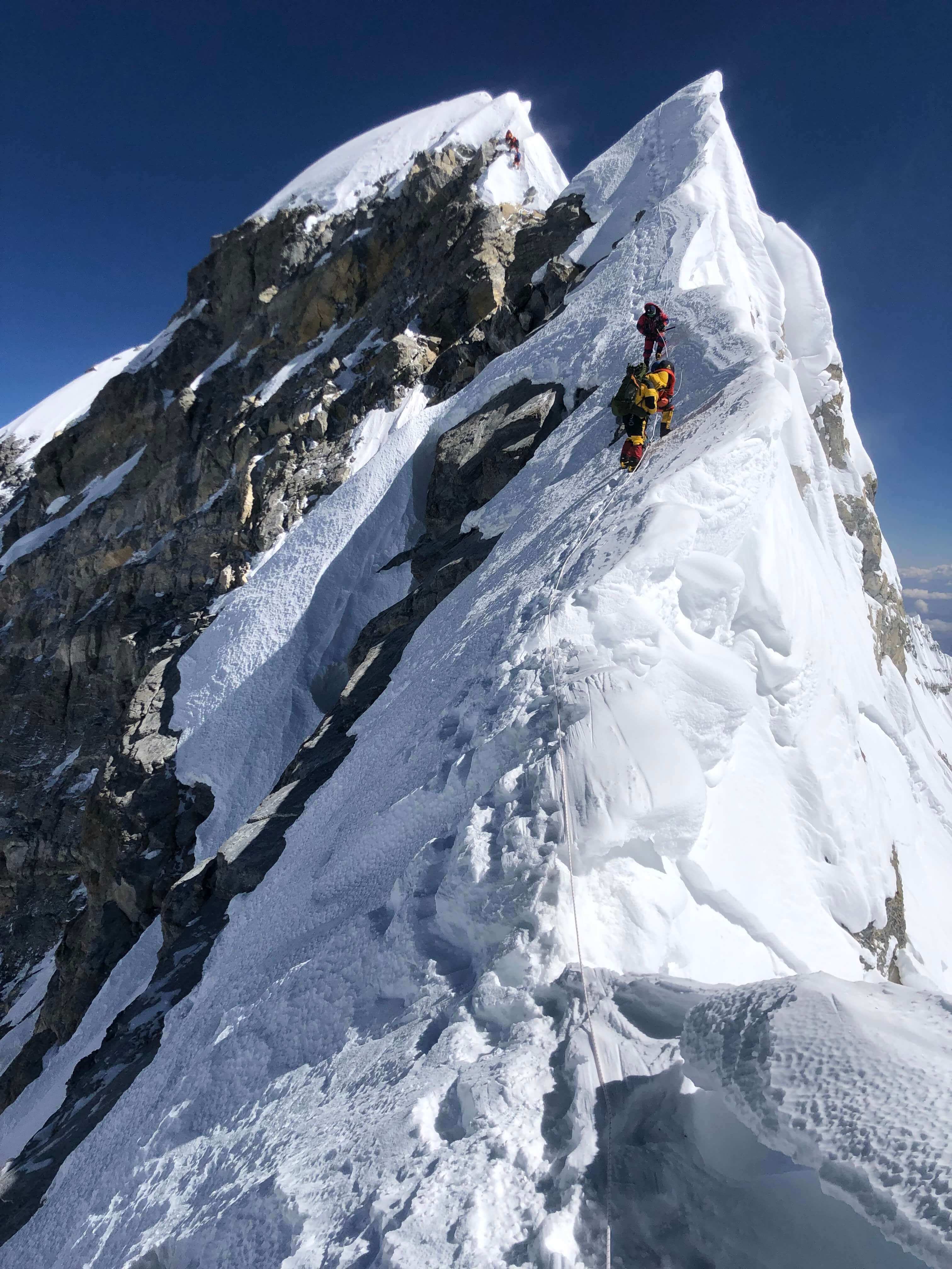
The Nepali survey expedition was led by Khim Lal Gautam, who climbed the mountain for the second time on 22 May 2019, to take measurements with GNSS and ground-penetrating radar. On the risky descent, Gautam nearly died of exposure at the South Col.
Why we climb mountains, Damien Francois
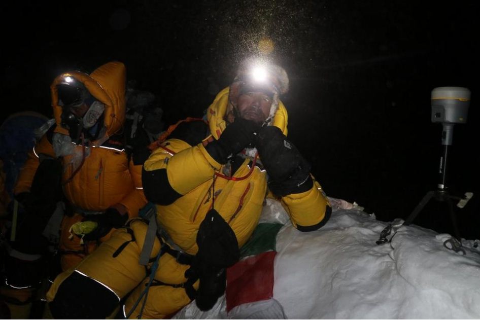
Gautam wrote in Nepali Times recently about the experience: ‘The near-death experience reminded me of the importance of the summit observation and the responsibility that I had in bringing down the data. We took risk for this raw data so we could get the precise height of Mt Everest.’
The Chinese also sent an expedition to climb Mt Everest in May this year – the only team on the mountain because of the pandemic. While the climbers were on top, a Chinese survey aircraft was flying overhead to take airborne gravity survey readings from the instruments on the summit. China said its equipment had “centimetre-level accuracy”.
China and Nepal signed an MoU to cooperate on the re-measurement, and had originally planned to jointly announce the height during President Xi Jinping’s visit to Kathmandu in October 2019.
K2, the second highest mountain the world in Pakistan is 8,611m, so there is no danger of Mt Everest being demoted any time soon. The famous Hillary Step on the southeast ridge of Everest that used to be the last steep hurdle for climbers, collapsed during 2015, showing that earthquakes do suddenly change the topography of mountains.
Everest Trail repaired during pandemic, Ang Rita Sherpa