
 |
 PICS: GORAKH BISTA |
But there is a silver lining, and it runs the length of Nepal. Many will have heard of the Great Himalaya Trail (GHT) by now, and know that in Nepal, it means an east-west trekking trail from Kanchenjunga to Api Himal. The mere idea can spark wistful dismissiveness. "160 days? I wish!" But look closer, and you'll see the GHT is not (though it can be) meant to expand lungs and disband careers in one six-month burst. It's divided into 10 sections across 16 districts – in the regions surrounding Kanchenjunga, Makalu-Barun, Everest-Rolwaling, Langtang-Helambu, Manaslu-Ganesh, Annapurna-Mustang, Dolpa, Rara-Jumla, Humla, and the Far West – that can be tackled in any number of permutations. Think of the myriad communities living along and around the 1,700km route that could benefit from an influx of teahouse and camping tourists, and you'll begin to understand that the GHT is far more than just 2011's flavour.
This year, I was fortunate enough to join a group of journalists and tour operators on a fortnight's trip to the Humla section of Nepal's G4HT with SNV, the Nepal Trust, and Firante Treks. The timing (at the end of the monsoon) was tricky, and highlighted the first and most obvious problem the new breed of GHTers might encounter this far west. We spent four days moping around in Birendranagar, Surkhet, waiting for the skies to clear there and up in Simikot, Humla's district headquarters. We appreciated the genuine attractions of Surkhet (a green valley, the temple ruins of Kakrebihar, and wetlands), but what we were really thankful for was the eventual clearing of the heavens.
 |
The SNV-led project to establish the GHT, which overlaps with the 162-day trek detailed by Robin Boustead in The Great Himalaya Trail: A Pictorial Guide, will be officially certified by the government by the end of 2010. But SNV, the GHT's co-funders (UK Aid, and UNWTO in west Nepal) and its local partners (Nepal Trust and Empowering Women in Nepal, in Humla) know all too well that designating an upper and lower GHT and promoting it are just part of an overall strategy. It's not enough to have tourists ready for the trail. The trail has to be ready for them, if one is to move beyond camping expeditions that too often bypass local communities.
Hoping to replicate the success of teahouse treks in the Annapurna and Everest regions, SNV and its local partners have been working to develop small to medium enterprises along the trail to provide food, lodging, and other trekking services. In 2009 and 2010, 50 small businesses in the pilot GHT sections of Humla and Dolpa received tourism-related training, covering everything from the importance of boiling water for drinking to dealing with altitude sickness.
 |
Humla's tourism infrastructure is still pretty basic. But one can only imagine how the first lodge in Namche started out. It's no small matter for Humli locals to venture into setting up teahouses on this relatively unfrequented trail. We were grateful for their gumption in undertaking to feed our group of 15 dalbhat, nettle soup, buckwheat pancakes, thukpa, and noodle soup. Rooms were available too, all the way to Hilsa at the border, though we camped throughout (as neither food nor lodging is commercially available in the Limi Valley yet).
It's early days, but clearly changes are afoot. As we passed newly fashioned wooden huts along the trail, men called out to us, offering us crunchy Humli apples and bottles of Coke. Back in Kathmandu, SNV Tourism Advisor Mim Hamal was upbeat when asked whether the training provided had made a difference. "Last year they were offering thirsty tourists beer, early in the morning. This year it's apples, water and Coke. They're learning how to
deal with tourists …if we get this right, and other kinds of development come to the Karnali region, it will eventually feed the rest of Nepal."
Island Humla
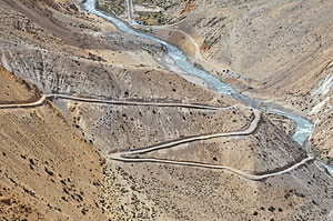 |
Simikot doesn't have any road access either. The district hasn't even been able to decide which way it wants to be connected to the China border, with the result that limited resources are alternately channelled into excavating roads from either Hilsa to Simikot (85km, see pic, with surfaced road at top on the Chinese side of the Karnali) or along the much less populated Lapcha to Simikot route (55km), depending on which constituency manages to loosen the state's purse-strings.
Eventually, the whole region should be serviced by roads, but for now it would make sense to focus on one uninterrupted link from the northern border to the district headquarters. Unfortunately, Humla currently has two incomplete sections snaking down from the border, of limited utility for most of its inhabitants. Quizzed about whether it made sense to promote a trail that might eventually be usurped by a road, à la Annapurna Circuit, SNV's Communication Officer Sanjib Chaudhary says that access can only be a good thing, especially for Indians travelling to and from Kailash.
Firante Trek's Janga Bahadur Lama is not worried, however: "It'll take at least 20 years for this road to be built. Maybe more."
Destination Humla
 |
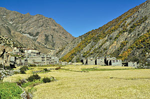
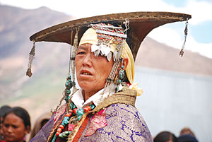
As we banked to land at 2,900m, Simikot spread out below us on a flattened hilltop amidst a colour-checked harvest expanse of fields. It was past midday, but we were raring to go, up the old noon ra oon (salt and wool) trading route to Tibet, or at any rate to the border. Soon we were trudging along the muddy trail between the towering green monoliths of the nettle-infested Hindu midlands, accompanied by the roaring quicksilver of the magnificent Karnali. We passed occasional tight clusters of mud-packed, flat-roofed houses where women with heavy gold and silver jewellery embroidered with colourful beads belied the obvious poverty. Thakuri men led flocks of long-haired, impressively horned goats down the trail to Simikot, many a home's Dasain treat.
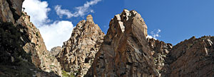
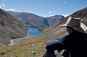
As we approached Hilsa and the northwestern border in the following days, the landscape became drier, and the context, Buddhist. After the desolate views around Hilsa, we made a circuit back southeast via the Limi Valley, through amazing red rock scapes haunted by blue sheep and huge vultures (pic, left). The three medieval stone settlements of Til, Halji and Jang were as isolated as anything we had seen. Then we passed the aquamarine Tshom Tsho, a shock in the dessicated high-altitude landscape, to nestle in the glacial valley below the Nyalu Pass. Finally, we crawled up to 5,000m, down past Selima Tsho, and into an astonishingly verdant birch and pine forest chittering with birds and a campsite in the shadow of a massive rock face, before rejoining the trail to Simikot above the Salli River.
The science of Kailash
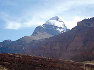 |
Humla has long been considered the gateway to sacred Mt. Kailash in Tibet. Thousands of pilgrims visit the mountain and the huge lakes, Mansarovar and Rakshas Tal, which give rise to the Brahmaputra, Indus, Sutlej, and the Karnali.
But Mt. Kailash is also part of a fragile landscape containing multiple ecosystems that host a number of endemic, endangered and relic species, as well as Buddhist, Bon po and Hindu communities that farm, rear livestock, and trade for a living. To consider Humla a mere gateway is to miss the bigger picture. In working towards conservation, sustainable use, and livelihood improvement over the 31,000
square kilometres of the Kailash Sacred Landscape Conservation Initiative (KSLCI), ICIMOD is living up to its mandate – integrated mountain development and transboundary cooperation.
With support from UNEP and in collaboration with lead partners in China, India and Nepal, ICIMOD's Environmental Change and Ecosystem Services team has come up with a conservation strategy for the region. This identifies gaps, major issues such as climate change, and the responses of local communities as well as flora and fauna. Long-term environmental monitoring (for instance through the establishment of meteorological and hydrological weather stations) will be an important component of the project, says Krishna Prasad Oli, regional coordinator for the project.
Oli warns that though the impact of tourists is low now, if the Great Himalaya Trail picks up then familiar problems – solid waste management, firewood use, littering, lifestyle impacts – will have to be addressed, along with issues of intellectual property and biopiracy in a region that has great scientific, economic and cultural potential.
He is keenly aware of the difficulties associated with transboundary cooperation in such a geopolitically sensitive region. But the groundwork is being laid, he says: "We have had tremendous cooperation from and valuable exchanges with scientists from India, China and Nepal. We have to begin with science, and hopefully the work we do will be the basis of policies that will guarantee the sustainability of the transboundary Kailash sacred region as a whole."
READ ALSO:
Manang's memories, MICHAL THOMA
The wars within
Becoming Humli, YOGI KAYASTHA